Route Editor

| Guide | ♦ | 1 Triplog | 0 Topics |
details | drive | permit | forecast | route |
stats |
photos | triplog | topics | location |
| 15 | 1 | 0 |
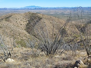
Sodom and Pozora by DixieFlyer  Overview OverviewThe Pozora Benchmark (elevation of 4,701 feet and prominence of 741 feet), is the highpoint of the Pozo Verde Mountains. This range is one of 193 mountain ranges that are fully or partly in Arizona. The benchmark is in southern Pima County, a few miles west of the Arizona town of Sasabe and a couple of miles north of the Mexican border. Etymology and History Pozo Verde is Spanish for "green well". In 1699 Father Kino called a location in these mountains Guvo Verde. "Guvo" is Papago for well, and the well had a green color. By 1863 a village with about 350 Papago Indians lived here. The native name for it was Chutukwaha, which means "green spring".
Source: Arizona's Names (X Marks the Place), by Byrd Howell Granger Hike The hike consists of two parts: a one-mile road walk followed by 0.65 miles of off-trail hiking. If you have a high clearance 4WD vehicle you could drive the road and make this a much shorter hike. However, the hike is not that long, and the road walking is easy and goes pretty fast. Once you get to the end of the road you will be looking up at the summit, which has some sort of communication tower on it -- probably border-related. Don't try to out-think this portion of the hike -- you just head uphill toward the summit and keep going until you get there; afterall, the shortest distance between two points is a straight line between the points. There is some vegetation to contend with, but you can weave around most of it. There are lots of cow trails or smugglers trails that you can use to avoid some if not most of the vegetation. There is quite a bit of ocotillo to weave around and through, but it is not too bad. As far as bushwhacking goes, this is pretty mild. However, it is suggested to dress a bit defensively -- long pants and a long-sleeved shirt will be sufficient. The slope is a bit steep, but the footing is good and it is all class-one hiking. Once at the summit, several large rocks make a good place to sit down and enjoy the expansive views. Return the way that you came. On the descent, you can take advantage of an elevated position and more easily stay on the cattle trails and use trails. The author of the guide hardly brushed up against any vegetation on the descent. Warning This hike is in close proximity to the US-Mexican border, and the author of the guide saw signs of illegal border crossing on the off-trail portion of the ascent -- mostly empty black one-gallon water bottles. This is not unusual to see while hiking in southern Arizona and is not something to be overly alarmed about. However, it is something to be aware of while on this hike. Check out the Official Route and Triplog. Leave No Trace and +Add a Triplog after your hike to support this local community. | |||||||||||||||||||||||||||||||||||||||||||||||||||||||||||||||||||||||||||||||||||||