Route Editor

| Guide | ♦ | 1 Triplog | 0 Topics |
details | drive | permit | forecast | route |
stats |
photos | triplog | topics | location |
| 57 | 1 | 0 |
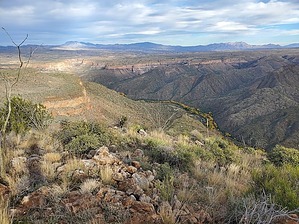
bird's eye view of foliage in late Fall by Mike_W  Overview OverviewBrandenburg Peak, at an elevation of 4,366 feet, is one of the northernmost peaks in the Galiuro Mountain range and can be accomplished in under 4 hours. The hike has a little bit of everything - it involves walking in a sandy wash, taking a cairned trail going up to a ridgeline, walking up an old 4x4 road, and then an off-trail scramble up to the summit with not a lot of obstacles or brush. Hike Starting heading northwest up the sandy wash. There are many side washes here and you might find yourself off the main wash at times. Simply cross back over to the main wash, which I had to do a few times. After hiking 0.9 miles the canyon will be closed in more and you should see a horizontal line of rocks in the sand that indicates there is a better route forward. To the right of these rocks, you should see a trail leading up and out of the canyon, which leads up to the main ridge going up to the peak.
Turn right at the 4x4 road and continue uphill for 0.55 miles. The road will climb up and then level off near the base of Brandenburg Mt. You will exit the 4x4 road on the left side and climb the slope from here. From the point that you exit the road, you should have roughly 0.75 miles to get to the peak. As you climb up, stay right of the rocky area. Once you get to the top of the ridge you will see the summit. You'll see a lot of shindagger, ocotillo, dry grass, some prickly pear, some cholla, and some palo verde. It's fairly easy to weave around this stuff because it is not so thick. At the high point, you'll see a registry in a rock pile. If you continue to the far east end of the summit, you will see some great views looking out. In mid-December, I could look down into the deep canyon below and see a lot of nice foliage including greens, yellows, browns, and some reds. The Galiuros are also home to Bassett Peak on the southeastern side, about 30 air miles away, which is known for foliage in November. Looking north you will see many vertical cliffs with many different colored rock formations. The views are something like the Grand Canyon on a much smaller scale. Take the same route back down to your starting point. BLM Division Details The start of the trail, which is located on E. Aravaipa Road, where the wash hits the road is located on BLM land. There is no permit required for this hike. The trail crosses into Arizona State Trust Land halfway up the wash and then back into BLM managed public land up on Brandenburg Mountain. There is no motorized travel allowed more than 50 feet of the center line of the road. Dispersed camping, mineral collection, target shooting, hunting, and other typical uses are allowed on public land, subject to rules and regulations. For any questions on the area, please contact the BLM Safford Field Office at 928-348-4400 or blm_az_sfoweb@blm.gov. Check out the Official Route and Triplog. Leave No Trace and +Add a Triplog after your hike to support this local community. | ||||||||||||||||||||||||||||||||||||||||||||||||||||||||||||||||||||||||||||||||||||||||