Route Editor

| Guide | ♦ | 3 Triplogs | 0 Topics |
details | drive | permit | forecast | route |
stats |
photos | triplogs | topics | location |
| 66 | 3 | 0 |
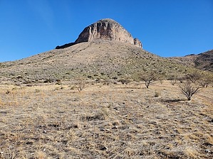
not named after Bruce Lee, Springsteen or Willis by Mike_W  Overview OverviewMt. Bruce, also known as "The Biscuit" to locals, is the northernmost peak in the Mustang Mountain range and is about 10 miles east of Sonoita, AZ. The elevation is 6087, which is not the high point in the range, but it is the most recognizable peak in the range. There's also a pretty good cairned trail leading to the top. You may see some grazing cattle in this area. Hike Start walking the road north for about 1/3 mile, then turn right heading east on another nicely graded dirt road. Take this road until you have traveled a total of 1.1 miles from your starting point and the road will appear to end. Look on the left side of the road for a cairned trail. This trail will lead up to the base of the rocky cliffs around Mt. Bruce. There will be some switchbacks but the trail will be quite steep. Once you get to the cliff edge, you'll see a climbing area with some bolts and rings embedded into the rocks. From here, the trail will continue north following the cliffs.
Take the same trail down going to the north. When you get down to the level of the trail going around the mountain, you will have a decision to make. If you plan on hiking only Mt. Bruce you will make a left and go back the same way you came up and your total round trip distance will be roughly 4.2 miles by the time you finish. You also have an option of summiting the peak that is roughly 0.5 miles south-southeast from Mt Bruce which is called North West Dome. There is no formal trail going there, but there were some decent animal trails. At the bottom of the cliffs, you can turn right and follow various use-trails around. The trails that go around the east side of the cliffs are more overgrown and harder to follow. You will need to drop down several hundred feet to get around the rocky cliffs on the east side of the mountain. There will be some brush to go around in some places and you may lose the trail at times. See my route if you would like to summit the North West Dome also. But, I won't go into any details on that peak since this is a guide for Mt Bruce. Ironically, Mt Bruce appears to look like a dome from a distance. So, someone unfamiliar with these peaks might mistakenly swap the names. History This mountain was named after Charles Bruce who was a businessman and politician. We heard there was some kind of memorial plaque near the trail but we didn't find it after searching for 30 minutes. If anyone knows what happened to the plaque, please send me a private message and I'll include a note. Check out the Official Route and Triplogs. Leave No Trace and +Add a Triplog after your hike to support this local community. | ||||||||||||||||||||||||||||||||||||||||||||||||||||||||||||||||||||||||||||||||||||||||