Route Editor

| Guide | ♦ | 4 Triplogs | 0 Topics |
details | drive | no permit | forecast | route |
stats |
photos | triplogs | topics | location |
| 0 | 4 | 0 |
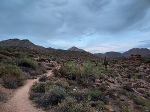
Climb and Punishment by DixieFlyer  Overview OverviewThompson Peak (elevation of 3,982 feet and prominence of 762 feet) is in the northern Phoenix Valley in the McDowell Mountains, and it is part of the Scottsdale McDowell Sonoran Preserve (MSP). Thompson Peak is the most recognizable and most well-known peak in the McDowell Mountains, even though it is only the 3rd highest peak in the range. Prologue This out-and-back hike starts and ends at the Adero Canyon Trailhead in Fountain Hills. The hike goes through three different preserves: * Fountain Hills McDowell Mountain Preserve (FHP) * McDowell Mountain Regional Park (MMRP) * Scottsdale McDowell Sonoran Preserve (MSP)
The route for this hike is presented below: 1) From the trailhead take the Promenade Trail north for 0.9 miles. 2) At the terminus of the Promenade Trail there is a fork that presents you with a choice: a) take the left fork and hike on the Sonoran Trail or b) take the right fork and hike on the Lower Sonoran Trail. Each trail is about 2 miles long, but the Lower Sonoran Trail has better tread and less up-and-down, so it is the easier trail of the 2. Many people will take one trail on the way to Thompson Peak and take the other trail on the way back. It is your choice. 3) After a couple of miles, the Sonoran Trail and the Lower Sonoran Trail will converge at the boundary for the MMRP. Continue on the Sonoran Trail for 0.8 miles until you come to a "T" junction with the Dixie Mine Trail. 4) Make a left turn on the Dixie Mine Trail and take it for 1.25 miles until you come to another "T" junction. At this junction, the Dixie Mine Trail continues to the right and Thompson Peak Road is to the left. 5) Make a left turn onto Thompson Peak Road. You'll be entering the MSP at this point. Thompson Peak Road goes to the summit of Thompson Peak, about 2.3 miles away. Stay on Thompson Peak Road all the way to the summit. Some sections of the road are very, very steep; it might be the steepest grade that you have encountered on a hike. Most of the road is dirt, but some of the steeper sections are paved to provide extra traction for service vehicles driving to the summit. 6) After resting and enjoying the views at the summit, reverse these steps to go back to the trailhead. Water Sources There is no water on the trail, so make sure that you bring plenty. There is virtually no shade out there, so there will be lots of sun exposure on a sunny day. Camping All three of these preserves are open during daylight hours only, so camping is not allowed. Synopsis The steepness of Thompson Peak Road will ensure that you get a good workout on this hike. Many people hike to Thompson Peak for a training hike for difficult hikes such as Grand Canyon Rim-to-Rim. There are nice views at the summit, but purists might scoff at the ambiance at the summit due to the antenna farm that is atop the peak. Check out the Official Route and Triplogs. Leave No Trace and +Add a Triplog after your hike to support this local community. | |||||||||||||||||||||||||||||||||||||||||||||||||||||||||||||||||||||||||||||||||||||