Route Editor

| Guide | ♦ | 2 Triplogs | 0 Topics |
details | drive | permit | forecast | route |
stats |
photos | triplogs | topics | location |
| 47 | 2 | 0 |
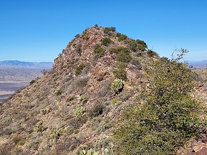
Lyons and tigers and bears, oh my! by DixieFlyer  Overview OverviewThis hike goes to the highpoint of the Johnny Lyon Hills, which are in northern Cochise County in a valley east of the Little Rincon Mountains. The unnamed highpoint has a spot elevation on topographic maps of 5,729 feet and it has a prominence of 1,149 feet. Eymology John Lyon was born in Maryland in 1856. He settled in this area, and he said that he arrived when "them hills was just little mounds." Mr. Lyon lived in a dugout with a bunch of hound dogs, complete with fleas. He once fell off a ledge and broke his hip. He managed to crawl to his dugout where he was found two weeks later. He recovered, sold his property, and lived to be a typical old hermit. Source: Arizona's Place Names (X Marks the Place), by Byrd Howell Granger
Once you go through the gate at the trailhead you'll be on a combination of private lands and state lands. Public access is permitted on the private and leased land, and to be legal on the state lands you'll need an Arizona State Land Trust recreational permit. From the trailhead hike about one mile on E Keith Ranch Road, and you'll gain about 500 feet in elevation during that mile. It is recommended to leave the road at the crest of a hill at about these coordinates: 32.12439, -110.23262. You could continue on the road another 1/4 mile or so to a clearing, but the road starts going downhill and you'd lose about 150 feet in elevation that you would have to regain later. If you look north when leaving the road you will see a ridgeline about 3/4 mile away. The summit is on the northwest side of that ridgeline, so your goal is to get on the ridgeline. You'll go cross country for a ways, crossing a few shallow drainages, arroyos, and bumps. There is some unfriendly brush in places that are mostly easy to get around. However, dressing defensively is a good idea. There are some cliff bands on the ridgeline, but there are weaknesses and gaps in the ridgeline that make good targets for the ascent. The author of the guide ascended to the ridgeline a little east of the point marked "5522" on topo maps and descended somewhat west of that point. That ascent was less steep than the descent, but it was more brushy. Pick your poison. The slopes to the ridgeline are fairly steep but not dangerously so. You will be hitting the ridgeline east of the summit, and you will go in a northwest direction to the summit. The ridgeline is rocky, so you'll be doing some scrambling along the way. However, there is nothing sketchy or technical and it is fairly easy class 2 scrambling. Depending on how adept you are at rock scrambling, the going might be a bit slow, but you'll eventually get to the peak. You won't be on the ridgeline for more than about 1/2 mile. There is a summit register log at the highpoint, so be sure to sign in. Most entries in the logbook are either peakbaggers or members of the Southern Arizona Hiking Club (SAHC). This peak is on the SAHC peak list. There are great views at the summit of several mountain ranges. Rincon Peak and Mica Mountain in the Rincons are not far away, and you'll also have nice views of the Santa Ritas, Santa Catalinas, Whetstones, Huachucas, Chiricahuas, and Pinalenos, among others. On the return, descend the ridgeline and go cross country back to the road, which you'll take back to the trailhead. Gate Policy: If a gate is closed upon arrival, leave it closed after you go through. If it is open, leave it open. Leaving a closed gate open may put cattle in danger. Closing an open gate may cut them off from water. Please be respectful, leave gates as found. The exception is signage on the gate directing you otherwise.
Check out the Official Route and Triplogs. Leave No Trace and +Add a Triplog after your hike to support this local community. | |||||||||||||||||||||||||||||||||||||||||||||||||||||||||||||||||||||||||||||||||||||