username
X
password
register
for free!
help
  
  🔥

Larry the Snail 4431, AZ

Guide 1 Triplog  0 Topics
  2 of 5  
Fav
Wish
1
details
drive
no permit
forecast
🔥
route  
stats
photos
triplog
topics
location
0 1 0
Statistics
tap row or icons for details
Difficulty 1 of 5
Route Finding 1 of 5
Distance Round Trip 1.71 miles
Trailhead Elevation 3,649 feet
Elevation Gain 735 feet
Accumulated Gain 874 feet
Avg Time Round Trip 2 hours
Kokopelli Seeds 6.08
 Interest Off-Trail Hiking & Peak
 Backpack Possible - Not Popular
feature photo
Photos Viewed All MineFollowing
2  2024-01-26
Larry the Snail and J K Mountain
pseudalpine
Author
author avatar Guides 59
Routes 1,100
Photos 1,191
Trips 1,290 map ( 9,859 miles )
Age Male Gender
Location Arizona
Historical Weather
Trailhead Forecast
Radar Map
Expand Map
Preferred Nov, Dec, Jan, Feb → 7 AM
Seasons   Autumn to Spring
Sun  6:01am - 6:44pm
Official Route
 
0 Alternative
 
Historic Fire Perimeteracres
🔥 2019 Woodbury Fire123.8k


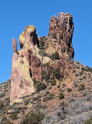
Stray Sea Snail with a Bad Attitude
by pseudalpine

  
Overview
This conspicuous spire can frequently be noticed from many places in the eastern Superstitions. Not to be confused with Gary the Snail, an unofficially named Grand Canyon summit located south of Siegfried Pyre. Larry was SpongeBob's rebound rescue after Gary decided to leave him and live with Patrick. Both of these snails "are really different than Jerry".


Approach
Depicted on the ©1997 Beartooth Maps topographic map, an old road is shown forking north from the Miles Ranch TH road (FR 287A). There's limited space for one vehicle along the road, which is two miles after one turns left from FR 287 of the mine area approach. Larry can easily be observed from this spot because of the road break in the jungly verdure.
remove free decal offer
Hike
Follow the old road north, past a jenky camp, where it transitions to a wash. After some short meanderings, several beaten-down cattle trails switchback up the ridgeline. These trails wander through the Catclaw Acacia and Mesquite, essentially leading to the base of the snail. One may scramble the slope between the Breccia and Rhyolite motifs, passing through a short tunnel before reaching a col that accesses the steep southeastern arete. Fairly solid and relatively easy class three climbing leads to the summit. An angry, barking, and hissing squirrel (Sandy Cheeks?) was near what I think may have been a cairn and I wouldn't be surprised if others have already been to this summit.

Synopsis
A unique peak when compared to the surrounding monotonous landscape with an easy, somewhat off-trail approach hike. The snail's eastern face could sport some minimally chossy technical climbs if one was so inclined to put in some effort.

2024-01-27 pseudalpine


    Check out the Official Route and Triplog.
    Leave No Trace and +Add a Triplog after your hike to support this local community.
    WARNING! Hiking and outdoor related sports can be dangerous. Be responsible and prepare for the trip. Study the area you are entering and plan accordingly. Dress for the current and unexpected weather changes. Take plenty of water. Never go alone. Make an itinerary with your plan(s), route(s), destination(s) and expected return time. Give your itinerary to trusted family and/or friends.

     Permit $$
    None


     Directions
    or
     Road
    High Clearance possible when dry

    To Miles Ranch Trailhead
    From Superior
    Head out east on US 60. Pass through the Queen Creek Tunnel and continue 10 miles to mile marker 239.4

    Turn left onto this paved road that enters the Pinto Mine. Follow the paved road 2.8 miles and turn left onto FS 287. Go slow at the numerous intersections. Your goal is to figure out which are mine roads and which are public access. Public access signs are posted on most of the intersections. Some aren't exactly clear which way they are pointing. You will leave the private land of the Pinto Mine and crossover onto forest land.

    At about seven miles, you turn left onto 287A. Follow FS 287A to the end. It's called Kennedy Ranch on maps, but the trailhead is called Miles Ranch.

    From PHX (I-10 & AZ-51) 88.0 mi - about 1 hour 53 mins
    From TUC (Jct 1-10 & Grant) 121 mi - about 2 hours 43 mins
    From FLG (Jct I-17 & I-40) 232 mi - about 3 hours 56 mins
    page created by pseudalpine on Jan 27 2024 6:53 am
     90+° 8am - 6pm kills
    helpcorrectionissue

    end of page marker