Route Editor

| Guide | ♦ | 1 Triplog | 0 Topics |
details | drive | no permit | forecast | 🔥 route |
stats |
photo | triplog | topics | location |
| 1 | 1 | 0 |
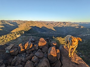
Sprinkled and Streaked with Gray by pseudalpine  Overview OverviewThe Powers Gulch and Pinto Creek drainages parallel each side of this middling interior Chaparral peak, where part of the southeastern Superstition Mountains are abruptly engulfed by the massively sprawling Pinto Valley Mine. The mountain itself is the classic Supes, reddish volcanic spuma, but it also seems like a type of gray limestone is interspersed throughout the area. Hike Begin at Gold Gulch and follow the Haunted Canyon #203 trail generally south along the Pinto Creek riparian for about 1.6 miles. An obvious fork splits left where there is a lift station for one of the mine's water pipelines. This road continues for a bit and then turns into a cow trail that follows Pinto Creek upstream. This is the only obscure point of the route, where one must head south, uphill, paralleling the rusting pipeline for a few hundred feet until reaching another old road, power poles, and their accompanying transmission lines. The tread is steep and rocky, since the unused road has significantly eroded, but isn't as bushwhacky, as if one was off-trailing through this grisly, mostly unburnt landscape.
Synopsis An interesting hike with surprisingly none of the mine visible until near the summit. The drone of heavy machinery can be heard constantly and occasionally the crashing sound of rock loads dumping. Military jets also blast through this area at low elevations, so overall it isn't a particularly peaceful hike. Note Roundtrip from Gold Gulch is about 5.5 miles in total. The official route is posted as a connector route from the Haunted Canyon #203 trail, thus the three-mile and ~200-foot AEG discrepancies. Check out the Official Route and Triplog. Leave No Trace and +Add a Triplog after your hike to support this local community. | ||||||||||||||||||||||||||||||||||||||||||||||||||||||||||||||||||||||||||||||||||||||||