Route Editor

| Guide | ♦ | 2 Triplogs | 0 Topics |
details | drive | no permit | forecast | 🔥 route |
stats |
photos | triplogs | topics | location |
| 41 | 2 | 0 |
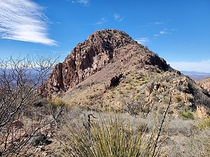
Pico de dos Perillas! (Peak of 2 knobs) by Mike_W  Overview OverviewThe South Perilla Mountains High Point (elev 5920) and the Perilla Benchmark (elev 5919) are two knobs about 1,000 feet apart, as the vulture flies. I say 'vulture' because you may see a few out there, as I did. When standing on either high point, it's impossible to tell which one is higher. Hiking to these high points is an open country hike with some class 2 scrambling near the top. There are some thorn bushes near the lower elevation areas and in the canyons, but many cattle trails are weaving through and around. As you get away from the canyon, the thorny brush disappears, but you'll be hiking through fields of rocks that never seem to end, and which make the hiking slower. Hike Follow the 4x4 road north. After about 500 feet from where I parked, the road will split. Take a left here going downhill. I followed the rocky road for a total of about 1/3 mile until it became a rocky trail. Follow the rocky trail along the hillside and eventually down into the canyon to your right. Then, after traveling a total of about 0.4 miles you will see an old windmill that looked destroyed and a small dam to block the water flow leaving pools of water for the cattle. Follow the canyon up until you have traveled a total of 0.6 miles. If the canyon is too brushy/thorny, you should find some decent cattle trails on the left or right sides that will follow the canyon.
Once at this saddle, I saw a fairly simple way up to the Perilla Benchmark by zip zagging a bit. At the top, I found a registry and a few US survey markers. I continued to the South Perilla Mountains high point which involved following the ridgeline for a while and then dropping down to the right side and heading toward the saddle between the 2 high points. Getting up to the high point was fairly similar to getting up to the benchmark, maybe even a bit easier. At the summit, I found a small medicine bottle that had another registry. I didn't see any US survey markers here, but either peak is a great place to take a rest or have lunch and admire the views all around. On the way down, I decided to not summit the benchmark again, but to hike around the northeast side of it. There were animal trails that went about halfway around, then I needed to zig-zag a bit. Eventually, I made it back to the saddle to the southeast of the benchmark. From here I followed the same way down except I decided to drop down into the canyon earlier which ended up being not so great of an idea. The canyon had a lot of thorn bushes, and the cattle trails were narrow, so I didn't stay there for too long. I ended up crossing the canyon and taking various cattle trails around and down to where I crossed the canyon earlier. Then, from here I took basically the same route back, staying in the canyon when it was clear and using cattle trails when needed. Once I got back to the 4x4 road, I knew I was home free. Check out the Official Route and Triplogs. Leave No Trace and +Add a Triplog after your hike to support this local community. | ||||||||||||||||||||||||||||||||||||||||||||||||||||||||||||||||||||||||||||||||||||||||||||||