Route Editor

| Guide | ♦ | 1 Triplog | 0 Topics |
details | drive | no permit | forecast | route |
stats |
photos | triplog | topics | location |
| 52 | 1 | 0 |
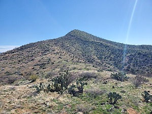
The "other" signal peak without the radio towers by Mike_W  Overview OverviewNot to be confused with the more famous Signal peak in the Pinal Mountains, Signal Peak in the Black Hills, at an elevation of 4,364, is located about 6 miles due West of the town of Mammoth, AZ. Keep in mind that there are multiple areas named "Black Hills" in Arizona. The hike will involve some dirt roads, some open canyon, cattle trails, and rolling hills. The good news is cattle have grazed a lot of this area, so you should be able to go around the thorny bushes and cactuses. You'll want to stay out of the narrow canyons and near the top of the ridges when there isn't a road to follow. The wide sandy canyons are fine also for walking in if they are going in the direction that you need to go. Hike Note: for this hike I also ascended the Grant Benchmark (elev 4323) which is about 1.4 miles north of Signal peak, as the crow flies.
At 0.7 miles I saw a road heading west, so I decided to take it, not knowing exactly where it would go. The road went uphill and ended after another 1/4 mile or so. The good news is the brush wasn't too thick around here. There was evidence that cattle grazed all through this area. I saw a high point to the west which I knew was not Signal Peak. The topo map had it labeled as BM 4323 which was slightly lower in elevation than Signal Peak at 4364. I continued hiking an open Country hike across some rolling hills and up in the direction of Peak 4323. When I got near the top, I saw a barbed wire fence which I had to crawl under. I went to the top and found a US survey marker with an arrow labeled Grant. So, this was the Grant Benchmark. The arrow pointed toward the high point but I did not see the official marker with the triangle symbol at the high point. At this point, my total mileage was at about 2.0. Looking south I could see Signal Peak. From here, it was 1.4 miles away. From here I decided to head down to the saddle which was southwest of the Grant Benchmark, and then head south along the ridgeline toward Signal Peak. There were a lot of rolling hills. I crossed a wash at 2.46 miles and another at 2.64 miles. After traveling a total of 3.05 miles, I reached a dirt road. I later discovered that I could have gotten on that road a while sooner, but at the time, I didn't know the road was there. I followed the road south for about 0.55 miles before the road ended at the top of a hill. This hill had an elevation of roughly 4211 feet. From here, I was only about 1/2 mile away from the summit, but I needed to cross a few rolling hills to get to the base of it first. I hiked right up the North Ridge which looked steep from lower down but I was able to zig zag and it wasn't too steep until the last 5 minutes of getting near the top. At the top, I found a glass jar registry that was not covered by any rocks. I signed the registry and put some rocks over the jar to reduce the amount of sun/heat damage to the contents. I saw one lonely poppy at the summit and some nice views of the snow-covered Mt Lemmon. There was a lot of black rock around which I suppose is why this area is called the Black Hills. On the way, down, I decided to take a different road going east. I noticed that the topo map had a BM 4066 which was not on top of any high point. I searched around this area and could not find any marker or reason why it was labeled as a benchmark. The topo map also showed a dashed line going east from this area but I didn't see any roads. I ended up doing an open Country hike east and then north. I kept looking for a road but later found a wide canyon which I suppose could have been what the dashed line was indicating. I dropped down into the canyon and saw tire tracks in areas where I would never even attempt to drive, even with my capable 4x4 HC truck. I kept following the wash down and saw an old tank and metal tower right outside the wash. Up ahead I saw 2 cattle resting in the shade and they may have been sleeping. When I got closer they heard me and took off. I continued and ran into a road crossing and turned left getting out of the wide sandy wash. I took the road back to the primitive gate and then back to where I parked. By this time, the campers were gone. I didn't see anyone else out there except for 1 other vehicle on the graded portion of the dirt road. If you're only interested in hiking to Signal Peak and not the Grant Benchmark, you could follow my "down route" and skip the loop. But, this would only reduce the round trip distance from 7.8 miles to roughly 7 miles. If you're looking for a shorter hike, and you have a capable 4x4 vehicle, you could drive in a bit closer but expect to see a lot of ruts and road erosion, especially in the 2/3 mile section before reaching the primitive gate. Gate Policy: If a gate is closed upon arrival, leave it closed after you go through. If it is open, leave it open. Leaving a closed gate open may put cattle in danger. Closing an open gate may cut them off from water. Please be respectful, leave gates as found. The exception is signage on the gate directing you otherwise. Check out the Official Route and Triplog. Leave No Trace and +Add a Triplog after your hike to support this local community. | ||||||||||||||||||||||||||||||||||||||||||||||||||||||||||||||||||||||||||||||||||||||||