username
X
password
register
for free!
help
  

Senita Basin Trail - OPCNM, AZ

Guide 1 Triplog  0 Topics
  4 of 5  
Fav
Wish
0
details
drive
permit
forecast
route  
stats
photos
triplog
topics
location
0 1 0
Statistics
tap row or icons for details
Difficulty 1 of 5
Route Finding 1 of 5
Distance Lasso-Loop 3.15 miles
Trailhead Elevation 1,667 feet
Elevation Gain 99 feet
Accumulated Gain 154 feet
Avg Time Round Trip 1.5 hours
Kokopelli Seeds 3.92
 Interest Historic
 Backpack Possible - Not Popular
 Dogs not allowed
feature photo
Photos Viewed All MineFollowing
22  2024-02-26
Sonoyta Mountains HP
DixieFlyer
Author
author avatar Guides 99
Routes 1,484
Photos 16,072
Trips 1,374 map ( 13,602 miles )
Age Male Gender
Location Fountain Hills, AZ
Historical Weather
Trailhead Forecast
Radar Map
Expand Map
Preferred Dec, Jan, Feb, Mar
Seasons   Late Autumn to Early Spring
Sun  6:09am - 6:51pm
Official Route
 
1 Alternative


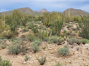
home of the whiskered cactus
by DixieFlyer

Overview
The Senita Basin Trail is in the Organ Pipe Cactus National Monument and is about 4 miles north of the US-Mexican border. This trail is noteworthy because it is one of the few places where you can see the rare and elusive senita cactus.


Hike
The Senita Basin Trail is a lasso loop hike. From the trailhead hike 1/4 mile to the beginning of the loop, which you can take either clockwise or counterclockwise.
remove free decal offer
The wide trail is well-marked, has good tread, and is easy to follow.

This trail can be used to access other trails and destinations, including Red Tanks Tinaja, the Baker Mine, the Victoria Mine, and Twin Peaks Campground. See triplogs for details on hikes that others have done.

Once back at the start of the loop, return to the trailhead the way that you came.

Water Sources
There is no water along this hike.

Camping
Backcountry camping is allowed with a permit.

Note
Dogs and bicycles are not allowed. Normal wilderness rules apply.

Warning
Given the close proximity to the international border, smugglers and illegal border crosses might be in the area. It is highly unlikely that you will encounter any indocumentados -- after all, they don't want to see you any more than you want to see them. Nonetheless, it is a good idea to be aware of your surroundings.

2024-02-27 DixieFlyer


    Check out the Official Route and Triplog.
    Leave No Trace and +Add a Triplog after your hike to support this local community.
    WARNING! Hiking and outdoor related sports can be dangerous. Be responsible and prepare for the trip. Study the area you are entering and plan accordingly. Dress for the current and unexpected weather changes. Take plenty of water. Never go alone. Make an itinerary with your plan(s), route(s), destination(s) and expected return time. Give your itinerary to trusted family and/or friends.

     Permit $$
    NPS

    Organ Pipe Cactus National Monument
    $15.00–$25.00 Fees & Passes

    Entry fees to the Organ Pipe Cactus National Monument are as follows:
    Private vehicles (including all occupants): $25
    Motorcycles (including passengers): $20
    Bicycles and Walk-ins: $15 per person

    The fees above are good for 7 consecutive days.

    Interagency passes are accepted in lieu of the above fees.

    Camping fees are as follows:
    Twin Peaks Campground: $20 per night (An established campground with facilities, tent, and RV camping.)
    Alamo Canyon Campground: $16 per night (A primitive campground for tent camping only.)
    Backcountry camping: $5 per permit (valid for 7 days)


     Directions
    or
     Road
    FR / Dirt Road / Gravel - Car Okay

    To hike
    The Senita Basin Trailhead is accessed from the eastern entrance to South Puerto Blanco Drive, which is a two-way, well-graded dirt road suitable for passenger cars unless it is very wet.

    From the town of Ajo, drive south on Highway 85 for 37 miles and turn right on South Puerto Blanco Drive, at a sign indicating that the International Border is one mile away. Travel on South Puerto Blanco Drive for 5 miles and turn right on the signed Senita Basin Road. Travel on Senita Basin Road for 4 miles to trailhead parking at the Senita Basin Picnic Area. Senita Basin Road is suitable for passenger vehicles in dry conditions.
    page created by DixieFlyer on Feb 27 2024 8:14 am
     90+° 8am - 6pm kills
    helpcorrectionissue

    end of page marker