Route Editor

| Guide | ♦ | 3 Triplogs | 0 Topics |
details | drive | permit | forecast | route |
stats |
photos | triplogs | topics | location |
| 238 | 3 | 0 |
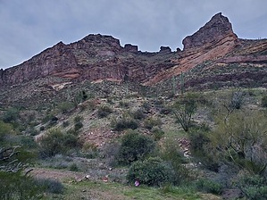
The bighorn sheep beat the World's record for the fastest descent! by Mike_W  Overview OverviewKino Peak, at an elevation of 3,197 feet, is in a remote part of the Organ Pipe National Monument about 20 miles south/southwest of Ajo, Arizona. The hike is quite long, involves long stretches of dirt road sometimes going through sandy washes, and involves some steep climbing up and down through rocky terrain with a few unstable areas. There are a few Class 3 climbing sections and a lot of Class 2+ hiking is involved so this hike is only for the more experienced hikers. You will need to carry all of the water you will need as there are no known water sources. During the 2 times I've been on this mountain, I've seen desert bighorn sheep fearlessly tearing down and across the cliffs with amazing precision and lightning speed! What takes us nearly an hour to hike might take them 5 minutes flat! History Kino Peak was named in 1945 in honor of Father Eusebio Francisco Kino (1645-1711), the "padre on horseback". Father Kino was the leader of the Jesuit missionary effort in this area in the late 1600s and early 1700s. He explored the area and worked closely with the Tohono O'odham tribe and was the first to prove that Baja, California was not an island but a peninsula by leading an expedition that went there.
There are several dispersed camping areas on Bates Well Rd south of AZ-85. This time we stayed 1.6 miles south of AZ-85 and about 1,000 feet east of Bates Well Rd. There were a lot of rules and fees involved for camping in the Organ Pipe National Monument area so we decided to skip all of the bureaucracy and just go with what was easier. Some of those rules included not being able to camp within 1/2 mile of any historical site (ex. Bates Well Ranch), or 1/2 mile from any road (ex. Bates Well Ranch). "Camp 1/2 mile away from roads, historic sites, or water source. Park only in the pullout specified on the registration form. No car camping allowed and driving or parking off designated roads is prohibited." - Some of this is rather contradictory and probably applies to designated campsites only. Prologue I first attempted this hike in April 2023 as a solo hike and could not complete it because of time. Last year, I made the mistake of starting this hike at Noon, not knowing how difficult and long it was. I turned around about 5 minutes after crossing the land bridge, at 5:15 pm, because I did not want to be on any difficult climbing section after dark. This time, Brian was able to join me on this challenging hike. We decided to camp 1.6 miles south of AZ-85, off Bates Well Rd, and get to the trailhead early, which ended up being 7:35 am, by the time we had breakfast, left camp and did the fairly long drive down Bates Well Rd. I highly recommend doing this hike with someone else. Hiking it alone can be dangerous. Hike From the place where we parked walk the road for about 0.5 miles until reaching a sandy wash. You should find tire tracks that enter this wash, turn, and head right(west) at the wash. Follow the wash until you have hiked a total of 1.1 miles since the start of this hike. Then, look for a road on the left side of the wash that exits to the wash and goes up to more solid ground. The road will be less sandy here and easier to walk. Continue on the road across mostly flat land. You should see a wash crossing after having traveled a total of 3.4 miles. At 3.63 miles, the road enters the wash and you'll stay in a wash for a while. Shortly after entering the wash you should be able to look south/southwest, in the direction of the peak, and see a variety of odd-shaped high points. From left to right, you should see a triangular point that's lower than all of the others, followed by a large rounded mountain, followed by a square-looking piece, followed by a triangular point that only looks higher because it's closer. The summit is behind the rounded mountain and quite a bit higher but it can't be seen from this angle. After the road enters the wash, you will continue for roughly one mile and then look for a trail that exits the wash to the south. I saw 2 possible trails exiting, one being further to the right. Take the path furthest to the right. You'll then be on a more narrow trail that leads to the east of Kino Peak. We saw some poppies along this trail and by this time, many were already open. Continue on this trail until you reach a huge saddle which is east of the summit. At this point, you should have traveled about 5.6 miles since the start. Looking up, the summit is above the high cliffs, but you will be able to go around those to the right. Here is where you will need to take a sharp right turn and start heading up. Start heading up the slope and look for cairns. I felt like there were not enough on this lower portion but higher up we did find some cairns which helped a lot. By the way, the route from this point is not trivial and not intuitive in any way. You will need a GPS device and you will need to rely on cairns. Expect to get off the trail a few times even if you're following a route on your GPS device. After going UP for about 1/4 mile you will see a large butte above you. You'll find a cairned trail that goes to the right of this butte. Once around the butte, the trail turns left and goes above the butte. Once above the butte, you should see more cairns leading up. Somewhere in this area, we saw a desert tortoise on the trail above us. I was only 5 feet away from the tortoise before I saw it. We got a video and continued following cairns up. Shortly after this, we found a natural arch/window right next to an organ pipe cactus. Next, we followed the trail up and around the left side of some cliffs. From here we could see the high point, but there was a rocky butte in front of it. But, we would need to hike around to the north side of this rocky butte to get past it. This is one area that we got off the trail and the cairns were spaced quite far apart. We ended up climbing up higher and higher, nearly summiting this rocky butte, but then we saw some cairns which led us around to the north side and around. We continued and met up with Wade's friend Ewon, who decided not to go any further at this point because up ahead was a steep Class 3 down climb through a messy rocky canyon followed by a Class 3 climb up and over to the land bridge. Before doing the class 3 down climb, we looked up and watched Wade, who was already on the steep climb going around the cliffs. From this angle, the climb looked dangerous, but obviously, we could not see what the trail looked like. We saw Wade reach the top ridgeline and disappear around the side, so then we decided to proceed with the Class 3 down climb. The Class 3 parts of the climb are short, but there's some exposure in these areas. There were a lot of good hand and foot holds and I felt comfortable enough to continue. Shortly after watching Wade disappear around to the top ridge, we saw 2 bighorn sheep moving across and down the cliff area. We saw them climb from way up high to way down low in about 3 minutes and then they were out of sight. That same hike for us, if even possible the way they went, would have taken us an hour. I recorded a 2-minute and 45-second video of the bighorn sheep. By the way, this is roughly the area where I saw 5 bighorn sheep last April of 2023. OK, now back to the class 3 section. First, you start off climbing down a narrow ledge to the right. Once down to that level, you make a sharp left and there's a 7-foot wall to climb down which was fairly easy because it was not completely vertical and there were some good rocks to use as hand and foot holds going down. Next, the trail goes down into a messy canyon. There's a lot of loose rock in this area so you will need to zig zag a bit. Straight ahead is a huge cliff wall going UP and a rock formation that's close to the cliff. I found it easier to go along the cliff wall and behind the rock formation. I kept going down, zig-zagging until I could look right and see a path leading over to a ledge. An organ pipe cactus arm extends out across this trail. I found it to be easier to go around it rather than under it. Because of the steepness, I didn't want to risk sliding or falling into any cactus. After going around the cactus arm, I continued over some rocks and onto a ledge. The ledge curved around the cliff side and once around this turn, we could see the land bridge. The erosion was quite bad below the land bridge, which made it look near impossible to climb it straight on, but I'm sure some people could do it. Since I was here before, I knew how to proceed. Right near the right turn on the ledge, you will see a rock formation that looks like a small cave. To the left of that area, there's a short class 3 climb up with good hand and foot holds that will get you up to a higher ledge where you can weave your way over to the land bridge. Once we got to the land bridge, it was already after Noon and we were ready for lunch. By this time, we saw Wade coming down the trail and watched his route. Some areas looked like cliffs and we didn't see how it was possible a trail could even exist there, but it did. We realized we could not see the depth from the angle we were at. We finished our lunch, crossed the land bridge, and met up with Wade, shortly after crossing the land bridge. He said the hardest part of the hike was probably the class 3 climbing that we just did in 2 places. It was a relief to hear that because we didn't know much about how the trail was going up from this point. Right in this area, I saw a brown rock hoodoo with a gray rock on top of it. This was about the place I turned around in April 2023 because it was getting late, around 5:15 pm, if I remember correctly. This time, we were here much earlier and I knew we had time to make the summit. Wade continued down to the land bridge and to the Class 3 sections, and we continued on the trail, looking for the next cairn. We were able to follow the trail pretty well, but there were a few areas of confusion along the way. At one point, we didn't see any more cairns, so we just climbed UP and that turned out to be the correct path. After following the trail up for a while, we reached the top ridgeline and knew the rest was going to be easier than what we just did. We noticed there were fewer cairns on the top but that was OK because from here, we knew we just had to follow the ridgeline up. The ridgeline was rocky in some places, so we stayed to the right of it, and in some places, we were right on top. We just took the path of least resistance. Up ahead we saw a high point that was not the true summit, but we decided it would only take a few minutes to get up there so we went for it. Then, once there we could see what looked like a small cave at the high point. We continued and the peak turned out to be a 10-foot-tall rocky knob. There was sort of a doorway where it was possible to step inside. We climbed up to the top of the knob and saw the US survey marker labeled TESMO, which was placed in 1962 and this was the official summit. There was a small ammo box that contained a registry which we signed. We also saw Wade's entry who signed it just before us. At this point, my GPS read 7.29 miles. It was a long way from where we started in the morning. I knew by the time we were done we could be at nearly 15 miles. We took a break, had some snacks, and hydrated. Then, got several photos, videos, etc. By this time, we had already been on the peak for nearly an hour. It was time to start heading back. We were very confident that we could make it down to the road well before dark. We basically took the same route back, and it took us just under 1 hour to get from the summit back to the land bridge. We took a short break at the land bridge, then continued across the class 3 climbing sections. It seemed to be a bit faster in this direction. I believe it took us around 35 minutes to get past those rough sections and back over to the northwest side of the butte. From here, we knew we could relax a bit because we had the hardest parts behind us. We continued down at a comfortable pace and got to the lower butte by about 5 pm. Then, got to the big saddle by 5:55 pm. It was still light out and we had only easy trail and road left. After it got dark, we put our headlamps on. On the road, on the way back, we saw 4 or 5 birds sitting on the road. All we could see was a red dot which was the eye. When we got closer, the birds flew away, sometimes we were able to get as close as 6 feet away before the birds would fly off. We also saw 2 rabbits in the road/trail which hopped off much sooner, potentially 40-50 feet away from us, and 2 frogs in the road/trail which were so camouflaged by the rock it was amazing. When the frog wasn't moving it was hard to tell what was a rock and what was a frog. We wondered how they survived out there with so little water. Finally, we made it back to the big wash near the end of the hike. From here we heard a lot of quail flying out of the big trees, even though they were safe being way above us. See my stats and timeline below for more details. My Stats: Distance (round trip): 14.75 miles AEG: 2,606 feet Moving time: 6 hrs 53 mins Elapsed time: 13 hrs 25 mins My Timeline: 7:35 am - started hike (0 miles) 7:46 am - reached wash; tracks went to the right (0.5 miles) 8:00 am - exited wash on the left side (1.13 miles) 8:28 am - crossed a wash (2.44 miles) 8:52 am - crossed another wash (3.4 miles) 8:58 am - road enters wash and stays there for a while (3.63 miles) 9:42 am - reached the end of road portion of hike (4.68 miles), exited wash using a trail heading south 10:12 am - took trail to saddle (5.61 miles), then started heading up the east ridge 10:31 am - just below butte, found cairns heading to the right of it (5.89 miles) 11:31 am - kept following the cairned trail up which was hard to follow in some places (6.31 miles) 12:00 pm - met Wade's friend Iwan (sp) before the class 3 scramble DOWN (6.46 miles) 12:21 pm - had first view of land bridge after going down a messy canyon area (6.53 miles) 12:24 pm - reached land bridge, decided to take a water break and lunch (6.55 miles) 1:00 pm - met Wade as he was coming down from the summit (6.68 miles) 1:05 pm - continued to climb up the cairned, sometimes steep trail across ledges to the high ridgeline 1:34 pm - reached the high ridgeline (6.97 miles) 1:48 pm - reached secondary high point (7.16 miles) 1:55 pm - arrived at summit, took a break, photos, videos, signed registry, etc. (7.29 miles) 2:45 pm - left peak (7.35 miles) 3:05 pm - turned right to get off main ridgeline heading back to land bridge (7.65 miles) 3:41 pm - reached land bridge again (7.97 miles) 4:18 pm - climbed around steep area, across ledge and up class 3 rocky canyon area which was easier going UP (8.14 miles) 5:05 pm - above butte, following trail on the left side (8.61 miles) 5:55 pm - back on the road/trail (9.21 miles) 6:25 pm - stopped for a water break and food break (10.11 miles) 6:44 pm - getting dark, so turned on headlamp (10.16 miles) 7:17 pm - road exits wash, finally (11.11 miles) 7:22 pm - road crosses wash (11.35 miles) 8:37 pm - road reaches wash, turned right (13.88 miles) 8:49 pm - road exits wash (14.32 miles) 8:58 pm - back at vehicle, starting point (14.75 miles) Check out the Official Route and Triplogs. Note This is a difficult hike. It would be insane to attempt this entire hike without prior experience hiking. Leave No Trace and +Add a Triplog after your hike to support this local community. | |||||||||||||||||||||||||||||||||||||||||||||||||||||||||||||||||||||||||||||||||||||||||||||||||||