Route Editor

| Guide | ♦ | 2 Triplogs | 0 Topics |
details | drive | no permit | forecast | 🔥 route |
stats |
photos | triplogs | topics | location |
| 6 | 2 | 0 |
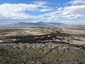
Chief Francisco's Last Stand by pseudalpine  Overview OverviewThis peak is located completely on Gila River Indian Community land, so respect their sovereignty and hike this route at your own discretion. It's an easy loop that integrates three of Pima Butte's (or “M” mountain's) highest points and their connecting ridgeline, which overlooks the solemn site of where The Battle of Maricopa Wells occurred. History Otherwise known as the Battle of Pima Butte, an area near this peak was the location where "irrationally perpetuating ancient and deeply entrenched hatreds" played out (C.M. Curtis, 2021[1]) between native North American tribes. Many dead allied Indians were left in the desert near here and this contrasts sharply with what the area now colloquially known as the Copa[2] has become.
The official route loops clockwise and starts by ascending the northeast ridge to ~1660, then follows the connecting col first southwest, then west to 1677. There's an active bee colony near the ~1652 surge in an obvious hole between the two peaks. One may want to steer clear of them, even though they were only slightly agitated by my presence as I passed. From the rocky quartz 1677 summit, the north ridge is a relatively easy descent back to a maze of social dirt tracks crisscrossing this small mountain's base. Synopsis Excessive vehicular noise from the highway, but unique, elevated views of the Sierra Estrella to the west and Table Top to the south. References 1) www.inmaricopa.com/battle-of-pima-butte 2) www.inmaricopa.com/copa-glow-night-market-and-hot-air-balloon-festival/ Check out the Official Route and Triplogs. Leave No Trace and +Add a Triplog after your hike to support this local community. | |||||||||||||||||||||||||||||||||||||||||||||||||||||||||||||||||||||||||||||||||||||||||||