Route Editor

| Guide | ♦ | 2 Triplogs | 0 Topics |
details | drive | no permit | forecast | 🔥 route |
stats |
photos | triplogs | topics | location |
| 12 | 2 | 0 |
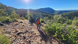
This horse loves to stirrup some trouble by DixieFlyer   Overview OverviewHorse Mountain (elevation of 6,440+ feet) is about 25 miles east of Payson in the Hellsgate Wilderness, and it is the highpoint of the wilderness. The hike is mostly on well-marked trails, but the last mile to the summit is off-trail through open country. Hike From the parking area just before crossing Tonto Creek, you'll first need to cross the creek on a bridge. There may be water flowing across the bridge, and if you want to keep your feet dry you may want to bring some water shoes for the crossing.
The hike starts with an uphill climb on Bear Flat Trail #178, and you'll get your heart pumping right off the bat. You'll gain about 600 feet of elevation in the first mile, with about half of that coming in one 1/4 mile stretch. After hiking about a mile you'll come to a trail junction with Mescal Ridge Trail #186, which goes to the right. When the author of the guide did this hike the sign was missing, although the signpost was there. Keep to the left to stay on the Bear Flat Trail. There is a lot of up-and-down on the Bear Flat Trail, and the trail is mostly an old jeep road. It is a pleasant hike in a forest, although there is some sun exposure along the way. About 4.25 miles into the hike you'll come to a trail junction with Big Ridge Trail #177. Take a right onto the Big Ridge Trail. Stay on the Big Ridge Trail for about 1.3 miles, at which point you'll go off-trail for about one mile to get to the Horse Mountain highpoint. Exit the trail somewhere around these coordinates: 34.25708, -111.02735 The off-trail portion loops around and approaches the summit from the south, which avoids having to drop in and out of some drainages. The hiking is open without any bushwhacking, and you can take advantage of some cattle and game trails along the way. The highpoint is not marked on topo maps, and it is somewhere in the 6,440'-6,480' foot closed contour shown on maps. The field observations of the author of the guide concluded that the highpoint is the northern part of the closed countour. The highpoint is not obvious, and if you want to tag the highpoint, about the best that you can do is wander around a bit and call it good. There are lots of trees at the summit so you won't have any jaw-dropping views. However, the summit area is still pleasant and is a nice place to stop for a break. This is an out-and-back hike, so return to the trailhead the same way that you came. Note that there is about 550 of elevation gain on the return, so you have a bit of work to do on the descent back to the trailhead. Synopsis This is a pleasant hike in a remote and rugged wilderness area, although there are not any impressive views at the summit. Thus, this hike is more about the journey than the destination. Gate Policy: If a gate is closed upon arrival, leave it closed after you go through. If it is open, leave it open. Leaving a closed gate open may put cattle in danger. Closing an open gate may cut them off from water. Please be respectful, leave gates as found. The exception is signage on the gate directing you otherwise. Check out the Official Route and Triplogs. Leave No Trace and +Add a Triplog after your hike to support this local community. | ||||||||||||||||||||||||||||||||||||||||||||||||||||||||||||||||||||||||||||||||||||||||||||||||||||||