Route Editor

| Guide | ♦ | 2 Triplogs | 0 Topics |
details | drive | no permit | forecast | route |
stats |
photos | triplogs | topics | location |
| 71 | 2 | 0 |
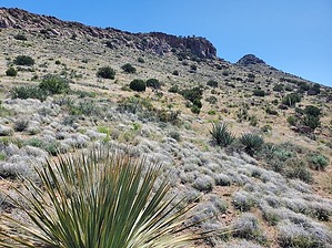
You don't need any cash to hike 'Ash' in a dash! by Mike_W  Overview OverviewAt an elevation of 5,585, Ash Peak is about 30 miles east of Safford, south of AZ-70, and is pretty easily accessible from the road. If you have a high clearance vehicle you can drive 1/2 mile south on a dirt road from AZ-70 to get to a good starting point. If not, you could start from AZ-70, making the entire hike about 1 mile longer. There is no trail for this hike. It's an open country hike but there were some animal trails and clean ridgelines which made the hike pleasant. Hike From the parking area do an open country hike S/SW for 0.4 miles. You will approach a wash up ahead. Cross it and get on the other side. From here we found some cattle trails which we followed west for about 1/4 mile. There were some amazing patches of poppies here in April. The object is to get around the rocky cliffs above. Once we got around the rocky sections, the ridgeline was pretty clear and we started going up. Up ahead the ridge got pretty rocky so we stayed to the right and aimed for another low saddle on the way to the peak. We could see a gap between the large rock formation along the ridge and the peak itself. That's the place we wanted to get to next. After getting closer, we did the steep open country hike up and through a gap near the rock ridgeline, then we turned right and found a smooth ridgeline heading right up to the summit. We found some interesting rocks in this area that had many small embedded spherical-shaped rocks in them. This is a good place to stop for a break as there are several large junipers and other trees here. We could see that near the summit it got quite steep and getting to the top involved a short class 3 section but it may have been possible to avoid this by going around.
Throughout the entire hike, we saw many interesting flowers in April including poppies, winding mariposa lilies (white), desert dandelion, shaggy fleabane, purple/blue sandwort, wild onion, Dakota mock vervain (or perhaps verbena), wavy-leaf paintbrush, long leaf Indian paintbrush, plains blackfoot (looked something like a daisy), hedgehog cactus, Rose's claret-cup cactus, Eaton's penstemon or firecracker penstemon (red), etc. We went back roughly the same way we took up and did that slightly faster. Check out the Official Route and Triplogs. Leave No Trace and +Add a Triplog after your hike to support this local community. | ||||||||||||||||||||||||||||||||||||||||||||||||||||||||||||||||||||||||||||||||||||||||