Route Editor

| Guide | ♦ | 1 Triplog | 0 Topics |
details | drive | no permit | forecast | route |
stats |
photos | triplog | topics | location |
| 48 | 1 | 0 |
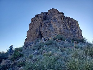
Under the tunnel, through the canyon, up the ridge - what a beaut! by Mike_W  Overview OverviewThumb Butte, which is on BLM land, has an elevation of 5188 feet but a prominence of only about 100 feet. When approaching the butte, it looks impossible to climb without ropes. But, there is a hiking route that is mostly class 1 & 2 hiking up to the base of the butte, and then mostly class 3 to get to the top, with little exposure. There is one class 3+ section of the climb with some exposure, so know your limit before you attempt this. Even if you choose not to summit the butte, it still is a great hike overall. Hike From the parking area, you will be hiking south. You can either cross the road or walk through a tunnel less than 200 feet east of the parking area. If you cross the road, you'll have to go under a barbed wire fence that is about 100 feet south of the road, but it's probably easier to take the tunnel, where you can easily go around a barbed wire fence and drop down from the concrete slab next to the end of the fence. Cross through the tunnel and you will be in a small canyon. Continue south for a few hundred feet and you will see a rocky canyon junction. Turn right here and continue for a few hundred feet. The ridge to your left is the ridge you will want to climb up. We found that it's best to stay near the center of the ridge in general. You will see a rocky area down low and you can get around that by staying to the left of it. Once around the rocky area go back to the middle of the ridge and continue up.
I found a slot going up on the north side which I knew I could get up. The problem was I could not see beyond the notch which was high up and I could not see the summit from that point. Brian came around and we looked at this approach. He said it looked better on the south side, so we both walked around, met up with Tim, and looked at it. This route looked much better and we could see that it led to the top. We found about 3 fairly good routes in this area. Basically, we hiked up to the first major tree where there was little exposure. After getting to the first tree, there was a class 3+ move with some exposure that I went up first. It was a bit scary and we just all took our time. After that class 3+ move, getting to the summit was easy. We found a registry in a rock pile with only 2 names in the last 12 years with the last entry being from 2021 and the entry before that being from 2012. After the 3 of us signed it, we became 2 of 5 that reached the summit in the last 12 years! We were a bit in disbelief that we were able to summit this one without needing any ropes or technical gear. On the way down, we all had to do a class 3+ move to drop down about 6 feet. It was an awkward position but we just took this slow and made it. I got a few photos of this area which might be helpful for anyone interested in summiting this butte. See my photo set for more info. We went down roughly the same route as we came up. I found the tunnel going under Hwy 70 on the way down which was an interesting way to end the hike. Check out the Official Route and Triplog. Leave No Trace and +Add a Triplog after your hike to support this local community. | ||||||||||||||||||||||||||||||||||||||||||||||||||||||||||||||||||||||||||||||||||||||||