 Route Editor

| Guide | ♦ | 1 Triplog | 0 Topics |
details | drive | no permit | forecast | route |
stats |
photos | triplog | topics | location |
| 0 | 1 | 0 |
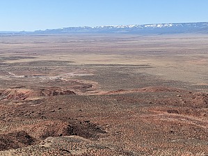
AKA East Crack by pseudalpine   Overview OverviewA befuddled joke app incorrectly lists this hike as the Sand Crack Trail. This somewhat amusing content gets two of the three words correct, which are labeled on the topo map, but the Sand Hill Crack is located farther west of this route. Nevertheless, this track isn't a particularly demanding hike in the proper conditions. If one attempts it in the hotter months, it'll probably seem like a difficult hike because of its lower elevation and mostly southern-orientated aspect. There is shade up near the route's terminus, but there's also a bunch of sand to slog through and sun to walk under before getting there. Hike Bear north from your vehicle(s) on the road, forthwith passing the dilapidated ranch house. The road turns more east and then north, working its way through the meandering canyon that splits the colorful kaleidoscope hills. Some plastic pipes are scattered along the way up to Rachels' Pools. On the left side of this vegetated spring area, the trail ascends a few brief switchbacks and then continues northeast up a steep and sandy ridge for another half mile and nearly a 300-foot gain. The path is easier for a bit as it bears southeast and then switchbacks up more rocky terrain to the base of the upper red sandstone escarpment. The final section follows a gully northeast past several petroglyphs and more recent engravings to the perplexing Sand Hills' hoodoos of the Paria Plateau.
If one doesn't have much time and/or it's blazing hot, an up and back of this route would be feasible in short order. If you have more time and it's cooler, a jamboree involving the western Sand Hill Crack and a traverse of the upper sandy plateau between the route's termini is a common hike that many people also complete. Check out the Official Route and Triplog. Leave No Trace and +Add a Triplog after your hike to support this local community. One-Way Notice This hike is listed as One-Way. When hiking several trails on a single "hike", log it with a generic name that describes the hike. Then link the trails traveled, check out the example. | |||||||||||||||||||||||||||||||||||||||||||||||||||||||||||||||||||||||||||||||||||||


