Route Editor

| Guide | ♦ | 1 Triplog | 0 Topics |
details | drive | no permit | forecast | route |
stats |
photos | triplog | topics | location |
| 20 | 1 | 0 |
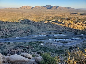
Toto, we're not in Texas anymore! by Mike_W   Overview OverviewPeak 5560 is one of the high points north of the Texas canyon rest stop east of Benson and has some very unique and beautiful rock formations. This relatively tiny range is called the Little Dragoons, not to be confused with the Dragoon mountain range south of the highway. The peak itself is on BLM land, but getting there may involve crossing some private property. Please see the note below about areas of private property. Note The land north of this rest stop appears to be a combination of BLM land and private land. We didn't see any "no trespassing" signs or even "private property" signs anywhere, so we assumed it was fine to walk around the fence near a drainage and hike from there. For the private land parcels in this area, please consult the Cochise County GIS data at https://gis-cochise.opendata.arcgis.com/
Hike Park in the Texas Canyon rest stop area North of Highway I-10. Start walking north to a fence line and follow it to the east. In a few minutes, you will see a drainage area and unfortunately, there was a lot of trash in this area. There was a concrete area with a barbed wire fence along the sides. Walk to the east corner of the drainage and follow the barbed wire fence for about 30 feet until you get to a ridgeline. Follow the ridgeline up and you will see a fairly good trail heading north. Eventually, you will need to get off the trail to climb to the ridgeline and then up to the summit. Your goal is to get on top of the ridgeline and climb up southwest, which is parallel to the highway. There are many ways to go and depending on your comfortable level, you can choose to go up wherever you feel you can. You should be able to zig-zag a bit to keep your angle of incline relatively low. You'll need to weave through some rock areas and boulders on the way up. There was nothing above class 2 climbing getting to this peak. See my route for one good way to go. Once on the ridge, it may be a little confusing where to go, but just keep climbing up and you will eventually get to the high point. We found a registry at the high point and signed our names. From this location, we could look down and see the Texas Canyon rest stop and many trucks. The boulder climbing and navigation were a bit tricky but fun. Looking northwest, you should be able to see Bluebird Peak which is about 2/3 air miles away. Check out the Official Route and Triplog. Note This is a moderately difficult hike. Leave No Trace and +Add a Triplog after your hike to support this local community. | |||||||||||||||||||||||||||||||||||||||||||||||||||||||||||||||||||||||||||||||||||||||||