Route Editor

| Guide | 0 Triplogs | 0 Topics |
details | drive | no permit | forecast | 🔥 route |
stats |
photos | triplogs | topics | location |
| 4 | 0 | 0 |
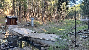
Is this thing even in use? by NitroTheWolf   Warning WarningWeirs can be dangerous, please be careful if you see a boil point. Weir has signs saying it is government/SRP property, so don't do anything stupid. Overview Very short hike to an old weir.
This is a watershed monitoring site. Inside the shack, "supposedly" scientific equipment monitors hydrological and meteorological conditions within the nearby area. Data from this site is transferred by radio. The unique identification code assigned to this site is: "WDS CNY" This equipment operates 24-hours per day and will collect watershed information about the effects of forest restoration activities planned for this area. If you have questions, you can contact SRP, 602-236-5592. Prologue The weir is located on a river. A wooden cable car connects the two sides together, presumably for maintenance when the river is running. There are two large white propane tanks on the east side of the river. They do not seem to be in use though. There is also a ~12' metal silo which I assume is where the river gauging equipment is stored. There is also a dilapidated wooden shack which probably sends the data to SRP. Hike GPS Track There is a faint trail to the weir, it can be very challenging to find though, I didn't even find it till I started back to the truck. The trail starts at the end of an old road, then somewhat curves for 0.1 miles till you reach a set of wooden ties/stairs that lead you down the slope to the weir. Water Sources There's water in the river occasionally. Synopsis This isn't much of a hike. If you're interested in dams and other old infrastructure, you might find it of interest. Check out the Official Route. Leave No Trace and +Add a Triplog after your hike to support this local community. | ||||||||||||||||||||||||||||||||||||||||||||||||||||||||||||||||||||||||||||||||||||||||||||||||||