Route Editor

| Guide | ♦ | 1 Triplog | 0 Topics |
details | drive | no permit | forecast | route |
stats |
photos | triplog | topics | location |
| 22 | 1 | 0 |
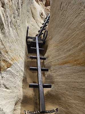
Mini Urban Slot by Vashti  A quick urban hike to a short slot canyon with steps and ladders. History Annie's Canyon was formerly private land accessed mainly by trespassers to party. The slot was covered in painted graffiti. The situation got worse after the location was posted on social media, and hordes of people started to trespass on private land to visit the slot which is just off I-5 north of San Diego. Something had to be done, and Annie (a long-time patron of the San Elijo Lagoon Conservancy) purchased the land and the slot formerly known as the mushroom caves officially became Annie's Canyon. The graffiti was removed as much as was possible, and the canyon was restored close to its original state along with enhancements deemed necessary for safety and accessibility. Annie's Canyon resides within the San Elijo Lagoon Reserve.
Annie's trail can be accessed from many different trailheads. This hike starts south of the San Elijo Lagoon Ecological Reserve. Parking is at the dead end of Solana Hills Drive. The Trailhead is just through the fence where a wooden sign shows the map and wildlife information. The trail is wide and easy to follow the entire route. The trail starts high above the I-5 freeway which it runs along for just under half a mile. The trail begins uphill before immediately going downhill and then uphill again before leaving the edge of the freeway and heading into the reserve. There is another large wooden sign with a map along with a smaller sign directing you toward Annie's Canyon. There are a lot of signs! Moving away from the freeway and into the reserve, there are some trees to provide a bit of shade before heading into the slot canyon loop. This is a welcome respite from the full sun exposure on the first half mile. There are also several wildflowers within the reserve which was an added bonus. Shortly after turning away from the freeway, you arrive at the Annie's Canyon loop on your left. There is another wooden map sign. And a giant wooden gate where the reserve presumably locks the gate to discourage trespassing each night. And another sign that says Annie's Canyon. You have officially arrived! A few steps onward there is another sign detailing the choices available to you. To the right is one-way traffic through the slot canyon and up two ladders to a viewpoint. This section is not difficult at all, though the sign lists it as difficult. This area is the highlight of the hike. The other choice is to go left at the sign and go directly to the viewpoint. Going through the slot canyon is one-way traffic from this point. For this hike, go right and into the canyon. After a short open section, the canyon narrows. This is a relatively short section and it isn't super narrow. I did not even have to turn sideways to get through. And the walls are not super high, so you can always see the sky. It does not feel claustrophobic. There are a number of side canyons, but they are all chained off with large "DANGER, unstable cliffs" signs. I have never seen anything like it. It was bizarre and not very wildernessy. 🤨 One side area is not blocked off, and that is the area known as mushroom cave. Though graffiti removal was attempted, some still exist at the top of the cave formation. Also, the paint was removed, but large sections of the soft sandstone have been carved into. 🙁 After the mushroom cave, you reach the end of the narrows and exit the slot through two metal ladders that are bolted on. After climbing up the ladders, you reach the viewpoint and continue down to finish the short Annie's Canyon loop. After exiting the Annie's Canyon area, you can head back to your car the same way you came in, or turn left on the Rios trail followed by a right onto the Gemma Parks Loop trail to hike along the lagoon before heading back to your car. This is a much better option as it is much more scenic along the lagoon. There are lots of wildflowers. Along the lagoon, we were treated to jumping fish. I didn't know that was a thing, but it was super cool! Many fish were jumping as we hiked along the lagoon. This turned out to be the true highlight of this trail. After a bit, the Gemma Parks Loop/Rios trails merge back with the Solana Hills Trail, and it is back towards the car. Gate Policy: If a gate is closed upon arrival, leave it closed after you go through. If it is open, leave it open. Leaving a closed gate open may put cattle in danger. Closing an open gate may cut them off from water. Please be respectful, leave gates as found. The exception is signage on the gate directing you otherwise. Check out the Official Route and Triplog. Leave No Trace and +Add a Triplog after your hike to support this local community. | ||||||||||||||||||||||||||||||||||||||||||||||||||||||||||||||||||||||||||||||||||