Route Editor

| Guide | ♦ | 1 Triplog | 0 Topics |
details | drive | no permit | forecast | 🔥 route |
stats |
photos | triplog | topics | location |
| 27 | 1 | 0 |
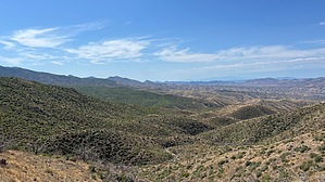
A long bumpy road with a view by NitroTheWolf  Warning WarningThis is a 4x4 trail, the first 5-15 miles require a 4wd high minimum. If you don't have it, you will not be able to make it. You'll be in the desert even if it doesn't feel like it. Please be careful of things that would hurt you, like cacti, scorpions, and snakes --- and the sun. Bring water.
FR 349 - 2 - 639 - 899 - 651: This 4x4 trail will take you to the scenic west side of the Pinal Mountains, up over the low pass in the Pinals, and down in the city of Globe..... Or reverse that if you start on the Globe side! Altitude starts at about 4000' on either end and climbs as high as 6000' over the pass. During winter months you'll likely find snow/ice on the higher elevations of the trail. History Mining has been a big source of income and work all over the greater Globe area. There are many small mines and diggings that have been long abandoned along this section. Bellevue mine, Black Rock mine, Sulfite/KB mine, and the Copper Vault Tunnel are some of the few major ones that you will pass by or explore if you take some side roads. Most if not all of these mines/diggings are abandoned, with some being sealed off. Remember, "Stay Out, Stay Alive." Drive The route I created while driving the track, others might exist, but the ones I've seen all are locked behind paywalls. Starting, the road is quite easy. FR 349 with it being maintained all the way to Simpson Lake and Ranch. At the junction near the lake, you will continue to follow FR 349. However, the trail becomes more faint and more rugged. If you're not in 4WD yet, turn it on, you will need it. The next 2 miles of the trail are mostly in the wash. There is an old mine along here that I recommend checking out. Farther ahead, the road splits into two halves. The top route is narrow, while the bottom route is wide and in the wash. These roads will rejoin each other in 1/4 mile. Do NOT attempt to take the narrow road in a full-sized car, you will NOT fit, there's a sheer drop off to the right and a sheer cliff to the left. Around the 7.5-mile mark, you will reach a junction. Turn left on FR 2. The hard part, in my opinion, is now over. This section will give you some great views of the surrounding mountains. Nothing technical here. Few switchbacks. You will continue along this road for about 2 miles. At the junction, head left on FR 349A/635. You will now continue on FR 349A/635 for six long and bumpy miles. You will pass two tanks, Lunn Tank and Lund Pasture Tank, which as of writing this, have water. Lots of cows near here, so drive carefully, and if you see one, there's guaranteed to be another nearby. Near Mile 12, your maps may show FR 2545 which leads to the Sulphide Del Rey campground. This road does not exist, do not attempt to drive it. Around May's Gap (Mile 14), there are a lot of switchbacks, so drive slowly. Lots of prospects and mines here too. Make sure to stay on track, there are many roads here that might show up on your maps, but not actually be drivable. Congrats, you have now made it to FR 899. The rough journey is now over. Take a left here and you will be on a straight shot to the Sulphide Del Rey campground area. You will gain around 2000' (over 5 miles on this road) of elevation on this road alone. At Mile 18 you will reach a junction. To continue past the camping area down to Globe, head east on FR 651. If you want, you can take a left on FR 580, which eventually deadends at a locked gate near the radio towers. Don't try to take this road to get to Miami like I thought. Once on FR 651, you don't need 4WD, so feel free to switch back to 2WD if you want. You will follow FR 651 for 5 miles until it reaches the paved road (Kellner Canyon Road). The trail is now over. To get back to Globe, take a right on Kellner Canyon Road. If you try to go left, you will reach a impassable barricade. Water Sources Lunn Tank and Lund Pasture Tank Camping Sulphide Del Rey is the campground located around 2/3 of the way through. Passes are not required to stay. 14-day limit and no trailers over 20 feet. No water, vault toilets (accessible), and no trash service. Check the Tonto Forest page for more information regarding this site. Gate Policy: If a gate is closed upon arrival, leave it closed after you go through. If it is open, leave it open. Leaving a closed gate open may put cattle in danger. Closing an open gate may cut them off from water. Please be respectful, leave gates as found. The exception is signage on the gate directing you otherwise. Check out the Official Route and Triplog. Leave No Trace and +Add a Triplog after your 4x4 trip to support this local community. | |||||||||||||||||||||||||||||||||||||||||||||||||||||||||||||||||||||||||||||||||||||||||||||||||||||||||