username
X
password
register
for free!
help
 This is likely a great time to hike this trail!  Check out "Preferred" months below, keep in mind this is an estimate.
  

The Americas Dock Trail - IRNP, MI

Guide 1 Triplog  0 Topics
  3.5 of 5  
Fav
Wish
0
details
drive
permit
forecast
route  
stats
photos
triplog
topics
location
0 1 0
HAZ reminds you to respect the ruins. Please read the Archaeological Resources Protection Act of 1979 & Ruins Etiquette
Statistics
tap row or icons for details
Difficulty 0.5 of 5
Route Finding 1 of 5
Distance Round Trip 0.3 miles
Trailhead Elevation 607 feet
Elevation Gain 11 feet
Accumulated Gain 11 feet
Avg Time Round Trip 14-20 minute
Kokopelli Seeds 0.36
 Interest Ruins & Historic
 Dogs not allowed
feature photo
Photos Viewed All MineFollowing
9  2024-08-16
Scoville Point Short
The_Eagle
Author
author avatar Guides 41
Routes 1,626
Photos 14,983
Trips 2,760 map ( 18,597 miles )
Age 69 Male Gender
Location Far NE Phoenix, Az
Historical Weather
Trailhead Forecast
Radar Map
Expand Map
Preferred Sep, May, Jun, Aug → 7 AM
Sun  6:17am - 7:28pm
Official Route
 
1 Alternative


At the bottom of the lake
by The_Eagle

 Likely In-Season!
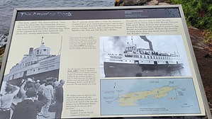
The hike to America's Dock on Isle Royale National Park is a short walk into the island's maritime history. This 0.3-mile round trip trail to the Americas Dock which collapsed into Snug Harbor in the winter of 2023/2024.


Starting at the Rock Harbor area, the trail is relatively flat and easy to follow. As you walk, you'll be surrounded by a mix of black spruce, balsam fir, paper birch, yellow birch trees, with the occasional sighting of local wildlife like red foxes or snowshoe hares.
remove free decal offer
America's Dock, located tip of Snug Harbor, was historically used by ships bringing supplies to the island's remote communities. The dock earned its name from the early 20th-century steamships like the SS America, which frequently docked here. The waters around Isle Royale are infamous for shipwrecks, with over 25 known wrecks, many caused by the unpredictable weather and hidden reefs. Some wrecks, like the SS America, are still visible near the dock, offering a haunting glimpse into the island's past.

2024-08-23 The_Eagle


    Check out the Official Route and Triplog.
    Leave No Trace and +Add a Triplog after your hike to support this local community.
    WARNING! Hiking and outdoor related sports can be dangerous. Be responsible and prepare for the trip. Study the area you are entering and plan accordingly. Dress for the current and unexpected weather changes. Take plenty of water. Never go alone. Make an itinerary with your plan(s), route(s), destination(s) and expected return time. Give your itinerary to trusted family and/or friends.

     Permit $$
    NPS


     Directions
    or
     Road
    Paved - Car Okay

    To hike
    To get to Isle Royale:

    By Ferry:
    From Houghton, Michigan:
    The Ranger III operates from Houghton and takes about 6 hours to reach Rock Harbor on the eastern side of the island.

    From Copper Harbor, Michigan:
    The Isle Royale Queen IV, operated by the National Park Service, also departs from Copper Harbor, Michigan, and takes about 3:45 hours to reach Rock Harbor.

    From Grand Portage, Minnesota:
    The Voyageur II and Sea Hunter III ferries operate from Grand Portage. The Voyageur II makes a longer trip around the island, with stops at Windigo and Rock Harbor, while the Sea Hunter III takes about 6:00 hours to reach Windigo, on the western side of the island.

    By Seaplane:
    From Houghton, Michigan, or Grand Marais, Minnesota:
    Isle Royale Seaplanes offer flights from Houghton, Michigan, and Grand Marais, Minnesota, to either Windigo or Rock Harbor. The flight takes about 30-45 minutes, offering stunning views of Lake Superior and Isle Royale.
    page created by The_Eagle on Aug 23 2024 4:18 pm
     90+° 8am - 6pm kills
    helpcorrectionissue

    end of page marker