The two trails merge near the wilderness boundary. The trail follows the East Fork of the Little Colorado River through a long meadow. The river has several pools created by beaver dams which are usually good fishing spots. If you don't have a fishing pole, or even if you do, maybe what you'll catch is a glimpse of a beaver going about its daily tasks. If you don't see one of these large, shy rodents, you can always console yourself with a variety of wildflowers that blanket the meadow from late spring through the summer.
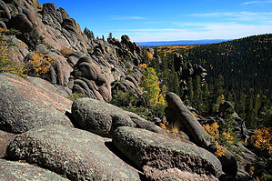
After following the meadow for about a mile and a half, the trail enters the timber. Here it begins to climb, and what a climb it is. The trail winds through a maze of sandstone boulders and stands of mixed conifer. In a half-mile of climbing, you will gain 800 feet in elevation. As if this were not enough reason to catch your breath, try the view. A reward usually comes to those who strive, and your reward will be a truly panoramic view. This view includes portions of the White Mountain Apache Reservation, Big Lake, Crescent Lake, a sizable chunk of the Black River Valley, Escudilla Mountain, the Blue Range, and on into the Gila National Forest in New Mexico. Few vantage points on the Forest offer a view like this. Hopefully, you brought a camera.
From this point, the trail follows a ridgeline on a continuous uphill grade, though it is a far more gradual climb than the one you've just been through. As the trail climbs, it alternates between timber and bare, rocky areas. About seven miles from the trailhead, this trail merges with the one from Sheeps Crossing. The two come together in a saddle below Mt. Thomas, nearly to the top of Mt. Baldy. The summit of Mt. Baldy is located on the White Mountain Apache Indian Reservation and is closed to all non-tribal members. From this point, you can choose to continue to Sheeps Crossing, about seven miles away, or to return the way you came. Many people like to hike up one trail and down another and make their lives easier by parking or shuttling their vehicles at each of the trailheads.
Note
Group size limits are 12 for hiking and riding and 6 for camping.
Lightning Kills
Stay off the mountain when thunderstorms are forecasted. July and August are notorious for quick unexpected storms. Lower the risk by being OFF the mountain before 11am on a clear morning. Stay safe, read the NOLS Backcountry Lightning Safety Guidelines.
When hiking several trails on a single "hike", log it with a generic name that describes the hike. Then link the trails traveled, check out the example.
WARNING! Hiking and outdoor related sports can be dangerous. Be responsible and prepare for the trip. Study the area you are entering and plan accordingly. Dress for the current and unexpected weather changes. Take plenty of water. Never go alone. Make an itinerary with your plan(s), route(s), destination(s) and expected return time. Give your itinerary to trusted family and/or friends.
Permit $$
None
Directions
Road
Paved - Car Okay
To East Baldy Trailhead From Phoenix area take highway 87 to Payson, then 260 to Sunrise junction, then State Road 273 about 10 miles to turn off for East Baldy Trail. On topo, it is between Gabaldon Horse Camp & Lee Valley Reservoir.
Start at the paved lot.
Snow Plowing
Highway Department typically plows Highway 273 past the ski area until December 31 but after which road is gated till often mid-April. Contact the Springerville highway department office at 928-333-4495 for the latest info.
Google Maps Search: East Baldy Trailhead, Greer, AZ
Tip
The East Baldy Trailhead can still be found on some maps under its former name of the Phelps Trailhead.
Alternative
Very unusual but if the lot is full please there is a secondary unpaved trailhead next door at Gabaldon Campground. It is reserved for horse camping but there's a small dirt area for general parking. The trails merge within a quarter of a mile of their respective starting points.
From PHX (I-10 & AZ-51) - 3 h 58 min (223 miles) From TUC (Jct 1-10 & Grant) - 4 h 29 min (233 miles) From FLG (Jct I-17 & I-40) - 3 h 8 min (187 miles)
 Route Editor


