 Route Editor

| Guide | ♦ | 1 Triplog | 0 Topics |
details | drive | permit | forecast | route |
stats |
photos | triplog | topics | location |
| 11 | 1 | 0 |
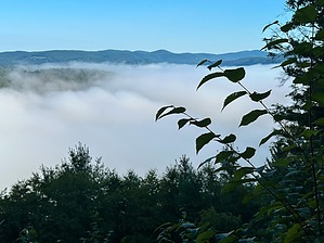
Not wilderness, but nice by GrangerGuy  The hike begins along US Highway 7, paralleling CT-4 as it heads east, then turning north over a scenic viewpoint and through bear country, then turning west, past a pair of beautiful waterfalls, and finishing with a challenging climb to Lookout Point, and then descending steeply back to US 7. History Much of the route of the Mohawk Trail was originally the Appalachian Trail in this area. You can still see a couple of benchmark-type AT medallions embedded in the rock in the middle of the trail. In the late 70s, Jimmy Carter signed the Appalachian Trail Bill, authorizing the purchasing of more land to protect the trail. At that time the AT was rerouted to the west of US 7 on a corridor that avoids private lands, and this trail was taken over by the Connecticut Forest and Parks Association as one of its "Blue-Blazed Trails", and renamed the Mohawk Trail, after Mohawk Mountain that it crosses. The trail has been rerouted in many places since.
If you want to do the whole trail, a good place to park is at the trail parking at the intersection of US 7 and CT 4. This is near the southern end of the trail. Start by climbing west about 0.8 miles to the summit of Bread Loaf Mountain, and then just a little beyond to the intersection with the AT. This is the true beginning of the trail. Then hike back down the hill, and begin a 3.5-mile walk on quiet roads. Cross the Housatonic River on the automobile bridge, walk a short distance on CT-4, and then turn left on Brook Road, which turns into Popple Swamp Road and is followed almost, but not quite, to its intersection with Route 4. The trail used to head up into the hills along Dark Entry Road, through the Wyantenock State Forest, eventually coming out at Cornwall Center. Issues arose with local landowners, and a large section of this trail was closed, leading to the Popple Swamp Road detour. Shortly after the intersection with W Road, and just after a small bridge, keep an eye out for the double blue blaze marking the trail suddenly leaving the road to the right and passing behind a barn. This recently blazed trail to Cornwall Center follows first on a mowed lane through the fields, and then on a new, rough but well-blazed path through a pretty wood. There is not much tread, but the blazes will tell you where to go. Eventually, the path reaches a T-intersection with the original trail. Go left out to the village at Cornwall Center, where you have another short road walk, before entering the Cathedral Pines Conservancy. After another short road walk, the trail follows a lane through a farm and then begins a steady climb up Mohawk Mountain to the summit of the ski area with good views. Head down the mountain to Mohawk Shelter 2, just short of CT-4 and a decent place to stay overnight. Crossing CT-4, and finally leaving it, the trail climbs up to Red Mountain and to a nice viewpoint just past it, before heading onto the newest section of the Mohawk Trail, just opened as this guide was being prepared in 2024. The trail switchbacks down, crossing a nice stream. Soon after, it passes a Collier Circle, a location where charcoal was made in the 18th and 19th centuries. The new trail ends at Johnson Road, which it follows for a short distance, re-entering the woods after crossing CT 43, and climbing to an overlook at 1426' Continuing north, the trail crosses Lake Road, and then through a couple miles of pretty wild trail. We saw lots of evidence of bears in this section. The brush encroaches a lot here as well. Just before turning west, the trail enters the Housatonic State Forest and passes near a large pond. Old maps and routes show the trail going to the pond, but it has been routed away from it due to beaver activity and swampy trail tread. The trail passes close to another marshy pond and then begins to follow a pretty brook which would be attractive for getting water, but the sides are steep. Wait, and the trail crosses the brook at a good spot to fill your bottles. Soon the trail begins to follow old forest roads, now closed to traffic, including the closed Wickwire Road for a long way. The trail turns off Wickwire for a mile or so on a brushy path that goes down in sight of Reed Brook, which looks attractive, but is a small bushwhack to get to open gravel bars. The trail climbs back up to Wickwire Road, passing Wickwire Shelter, which is a little run down, but a good distance to stop for a second night. The trail goes up the right-hand side of the shelter as you face it. It is not obvious. The trail passes near but not over Music Mountain. You can take a short bushwhack to the summit, but it isn't impressive from the top. Continue down off the west end of the mountain to Music Mountain Road, where there is a nice waterfall on Reed Brook, easily photographed from the road. Crossing the road, the trail descends sharply to the base of a second waterfall into Dean's Ravine, which has many camping possibilities. The trail drops down and follows Music Mountain Road for a short distance, and then turns straight north on some challenging trail. It climbs up over the shoulder of Barrack Mountain (1276'), then down into a drainage, then steeply up to Lookout Point. There is a nice view here, but the trail up on the south side and down on the west side are typical New England Trail, created before the invention of the switchback. Finally, the trail descends to Route 7, crosses it, and continues over to Warren Turnpike Road, where it ends in its intersection with the AT. Water Sources Water is easily found on this trek, but not conveniently at camping spots. Fill your water bottles when you cross the streams. All water should be treated. Camping The first camping on this route is Mohawk Shelter 3, just past the ski area. A mile or so later is Mohawk Shelter 2, just before crossing CT-4. All camping on this route requires reservations through the CT-DEEP, which they request 2 weeks in advance, although shorter times may be achieved if you call. As both shelters are close to roads, they are not really a wilderness experience. Wickwire Shelter is the next opportunity, is more remote, and is a bit run down. Tenting is possible in front of Wickwire. Dean's Ravine offers the last camping on this trail in a broad flat area just below the waterfalls on Reed Brook. Check out the Official Route and Triplog. Leave No Trace and +Add a Triplog after your hike to support this local community. One-Way Notice This hike is listed as One-Way. When hiking several trails on a single "hike", log it with a generic name that describes the hike. Then link the trails traveled, check out the example. | |||||||||||||||||||||||||||||||||||||||||||||||||||||||||||||||||||||||||||||||||||||||||


