 Route Editor

| Guide | 0 Triplogs | 0 Topics |
details | drive | no permit | forecast | route |
stats |
photos | triplogs | topics | location |
| 8 | 0 | 0 |
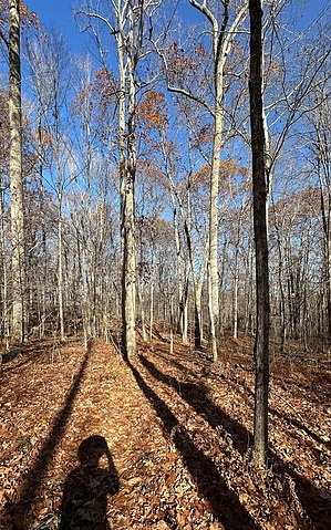
CCC this really nice trail by GrangerGuy This trail runs north/south through the southern and central sections of the Cockaponset State Forest. The trail is generally gentle but does climb a few granite stairs. It passes near the dam of the Pattaconk Reservoir and intersects many other trails giving options for a variety of trips. In June, the mountain laurel at the north end should be spectacular. History According to the official state website, the forest is named after an Indian Chief who is buried in the Ponset section in Haddam. The trail is very old, as can be seen by axe blazes in the trees. The CCC did a lot of work on the trail in 1934. They installed really nice granite steps in places, making the climbing and descent easy. Along the way, you will encounter the footings of the Turkey Hill fire tower and a site marked as an old charcoal-making ruin.
Starting from the south trailhead on CT-148, the trail heads generally north. In about an eighth of a mile is the first of several intersections with the blue-red trail. Keep following the blue blazes the whole way. At about 1.5 miles, one encounters the dam and parking at the outlet of the Pattaconk Reservoir. Leaving the dam, the trail follows along the hill above the reservoir, which is only visible through the trees in winter. If you want good views of the water, take the alternate blue-red Wildwood Trail along the shore and meet up with the Cockaponset Trail a mile later. At around 4 miles, you will find signs indicating the remains of a Collier Camp and a Collier Circle, where charcoal was once made. At about 5.4 miles you encounter the footings of the old Turkey Hill Fire Tower. A little beyond, the trail crosses a series of ridges and ravines. It's a little challenging but not bad. Check out the Official Route. Leave No Trace and +Add a Triplog after your hike to support this local community. One-Way Notice This hike is listed as One-Way. When hiking several trails on a single "hike", log it with a generic name that describes the hike. Then link the trails traveled, check out the example. | ||||||||||||||||||||||||||||||||||||||||||||||||||||||||||||||||||||||||||||||||||||||||||||


