|
tap row or icons for details
|
| Difficulty |
|
0.5 of 5 |
| Route Finding |
|
1 of 5 |
| Distance One Way |
|
1.02 miles |
| Trailhead Elevation |
|
1,004 feet |
| Elevation Gain |
|
-16 feet |
| Kokopelli Seeds |
|
1.05 |
| Interest Perennial Creek | | Backpack No | |
| | |
|
|
| |
|
|
Historical Weather |
| Trailhead Forecast | | |
|
 |
|
|
| Preferred Aug, Sep, Oct, Nov → 7 AM |
| |
|
|
| | |
| |
Named Locations Coordinate Links
| |
|
|
Harmony Trail - Allegheny
|
2.31 mi
180 ft |
 |
| | |
| |
|
|
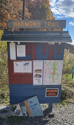
 The Harmony Trail is a little over one mile long, crushed stone, flat, scenic path. It parallels the Wexford Run stream between Route 910 and Richard Road. The west side of the trail is the face of a hill covered in trees and shrubbery. You can't see the neighborhoods perched on top when the trees are full. The east side of the trail is Wexford Run. The water flows pretty steadily even in the warmest months. Small fish and frogs live in the deeper ponds accessible by the many short offshoots that get you to the stream edge. About a half mile in is the connection with the Rachel Carson Trail that takes you across Allegheny County for approximately 45 miles. The Harmony Trail connects to the still being developed Commodore Perry Regional Trail that will extend through Pine, Marshall, Bradford Woods, Cranberry, Jackson, and Adams. It also follows the same corridor used by the Harmony interurban trolley from 1908 to 1931. One-Way NoticeThis hike is listed as One-Way. When hiking several trails on a single "hike", log it with a generic name that describes the hike. Then link the trails traveled, check out the example. |
 Route Editor


