username
X
password
register
for free!
help
 
  🔥

Orohai Mini Loop, AZ

Guide 1 Triplog  0 Topics
  3 of 5  
Fav
Wish
0
details
drive
no permit
forecast
🔥
route  
stats
photos
triplog
topics
location
3 1 0
Statistics
tap row or icons for details
Difficulty 1.5 of 5
Route Finding 2 of 5
Distance Multi-Loop 4.1 miles
Trailhead Elevation 2,081 feet
Elevation Gain 450 feet
Avg Time Round Trip 2 hours
Kokopelli Seeds 6.35
 Backpack Possible - Not Popular
feature photo
Photos Viewed All MineFollowing
3  2024-12-14 jregan0502
Author
author avatar Guides 1
Routes 1
Photos 17
Trips 17 map ( 63 miles )
Age 31 Male Gender
Location Phoenix
Historical Weather
Trailhead Forecast
Radar Map
Expand Map
Preferred Dec, Jan, Feb, Mar → 7 AM
Seasons   Autumn to Spring
Sun  6:02am - 6:48pm
Official Route
 
0 Alternative
 
Historic Fire Perimetersacres
🔥 Gost 20055.4 mi*
🔥 2005 Ghost5.4 mi*
🔥 View (All) - over Official Route 🔥
*perimeter length in miles


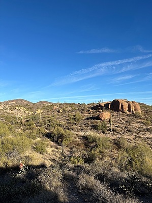
mountains with mountains
by jregan0502

 
Overview
The Goldfield Mountains are underrated for hikers, especially those who want an easier hike without being on a crowded city trail. Close to the Goldfield Ghost Town and 25 minutes from Tortilla Flat, the area is a great spot for a half-day hike and lunch. This is a relatively popular OHV area so route finding at the start of the hike isn’t the clearest but the NFS has placed trail markers in good spots along the trails to find your way.


Hike
The hike starts at the Hackamore Gate/Hackamore Staging Area, just north of the Treasure Chest Granite Pit, and heads immediately west for a few hundred feet before turning north. You'll be following Trail 309 which is, at this point, a 4x4 track. The trail then turns north heading towards a hill about 0.5-miles north. There’s a great geocache location on the southern face of the hill. The trail skirts the east side of the hill and heads towards the green thumb, a chartreuse lichen-covered pillar. Just north of the green thumb, the trail heads off the 4x4 to the west and tracks above an arroyo along the southwest face of a ridge before climbing north to reconnect with the 4x4 track. Follow the 4x4 track as it heads quickly northwest, then turning north momentarily. Stay on the 4x4 track as it heads northeast and becomes Trail 311.
remove free decal offer
After 0.35-miles, the trail catches up with a dry creek bed and turns southeast where, after about 0.17 miles it crosses MT (Motorized Trail)-3512. From this intersection, the trail becomes a singletrack and heads generally southeast. Flatiron guards the Superstitions in the distance before you. Trail markers set up by the NFS are more obvious on this side of the loop. In roughly 1-mile, Trail 311 intersects Trail 312. Follow Trail 312 directly west as it turns southwest along a hillside before temporarily joining Trail 313 for a few hundred feet in an abrupt turn northeast. Pay attention as Trail 312 then heads west off Trail 313 and turns south towards the Tonto NF boundary. Once reaching the boundary, the trail becomes a 4x4 track again and heads straight west along the fence to the Hackamore Gate/Staging Area.

2024-12-15 jregan0502


    Check out the Official Route and Triplog.
    Leave No Trace and +Add a Triplog after your hike to support this local community.
    WARNING! Hiking and outdoor related sports can be dangerous. Be responsible and prepare for the trip. Study the area you are entering and plan accordingly. Dress for the current and unexpected weather changes. Take plenty of water. Never go alone. Make an itinerary with your plan(s), route(s), destination(s) and expected return time. Give your itinerary to trusted family and/or friends.

     Permit $$
    None


     Directions
    or
     Road
    FR / Dirt Road / Gravel - Car Okay

    To hike
    From Phoenix: head east on US-60 to the Idaho Road exit. Head north into Apache Junction and take the Apache Trail northeast to Hackamore Road and turn left (north). The road dead ends at the Hackamore Gate.
    page created by jregan0502 on Dec 15 2024 1:04 pm
     90+° 8am - 6pm kills
    helpcorrectionissue

    end of page marker