Route Editor

| Guide | ♦ | 1 Triplog | 0 Topics |
details | drive | no permit | forecast | route |
stats |
photos | triplog | topics | location |
| 85 | 1 | 0 |
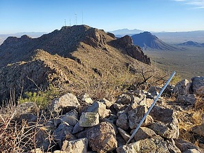
There's no trail but there is an END! by Mike_W  Overview OverviewTrail's End peak, at an elevation of 4,395 feet, is the second highest peak in the Tucson mountains, which is short of Wasson Peak at 4,687 feet, nearly 300 feet higher. Trail's End Peak is the peak that has all of the radio towers and antennas that can be seen from almost anywhere in Tucson looking west. Some people walk Trail's End road, which is a private road, but there's not a lot of challenge in that. It's definitely more of a challenge to hike it from the backside (west side). There's a great trail called the Orcut Trail which gets you 2.3 miles along the way, but the remaining 1.5 miles is an open Country bushwhack across some rugged terrain including deep canyons and steep rocky slopes. On the way down, you could go the same way back or do a lasso loop, follow the rocky messy ridgeline north, and stop at Non-Persondatory Peak. This is definitely not an easy hike and route finding may be difficult at times. Hike From the Ringtail trailhead, you'll see a sign for the Orcut Trail which heads north for the first 0.45 miles and then turns to the right after that and heads east for the next 0.45 miles. There's an archery range to the south of this second portion with some warning signs. Stay on the well-maintained trail for a total of 2.3 miles. You will see a forest service boundary fence and some signs. Just before the boundary, turn right and within about 100 feet you will see a deep canyon. Part of it will look like a slot canyon here with a steep rocky side. But, you will see a faint trail angling down into the canyon. Take this trail which leads south and continue another 50 feet to a junction. From this junction climb up out of the canyon and up onto a ridge.
Eventually, I saw the power lines up ahead. They seemed to go all the way up to Trail's End Peak. From the angle I was at, it appeared that the easiest way to the summit was to follow the power lines. The steepness didn't look too bad, even though there were lower saddles north of Trail's End peak. I continued across toward the powerlines and found myself having to cross one more large wash. I found an angled path out and got on the ridgeline and continued up. The terrain had a lot of dirt and not so much rock. The higher I got up, the more rocks and boulders I had to hike through. The terrain got a bit steeper and I needed to zig-zag a bit. At times I found myself directly under the power lines. I wondered how they ever got machinery in that area to install the powerlines, and what kind of machinery it was. The final 500 feet was a class 3 climb where I had to use my hands in many areas. I tried to stay away from the gravel because it got quite slippery and unstable. At the very end, I stayed to the right and followed the edge of a huge boulder up to the top. I climbed up to the fence that was enclosing some of the radio towers. This seemed to be the high point, although I didn't see any US survey markers or registries anywhere. There were signs along the fence stating that the radio wave exposure was above the FCC limit for humans, but I felt safe and decided I would not stay long. What about all of the people who live and work up there? From the top, I decided I did not want to go down that incredibly steep slope that I came up, so I decided that I would head north along the ridgeline and visit Non-Persondatory peak, which is a peak that I've been to before. There is no trail along the ridgeline and the ridgeline is very rocky and even can be dangerous if you don't go the correct way. At times, you will need to drop left or right of the ridgeline to go around some steep cliffs. But, there is a way. Expect that it will take you at least 1 to 1.5 hours to get from Trail's End peak to Non-Persondatory Peak. The distance is only 0.7 miles, but the terrain is very rugged. After having done the full loop, I'm not sure if it was any easier than it would have been had I carefully gone back down the way I came. There are definitely a lot of obstacles and you will need to have good route-finding skills. Follow my route and it will get you down from there. You'll see a 6-7 foot tall concrete dam way down below in a canyon, and to the east of that dam is a trail heading south. About 500 feet south of the dam, along the trail, you will see an old concrete foundation. Keep following the trail south and you will see the forest service boundary and the Orcut Trail basically continues from there. Follow the Orcut Trail 2.3 miles back the way you came. The Orcut Trail does not seem to have an official end to it.
Check out the Official Route and Triplog. Note This is a difficult hike. Arrive fit and prepared or this could get ugly. Leave No Trace and +Add a Triplog after your hike to support this local community. | |||||||||||||||||||||||||||||||||||||||||||||||||||||||||||||||||||||||||||||||||||||||||||||||