 Route Editor

| Guide | ♦ | 1 Triplog | 0 Topics |
details | drive | no permit | forecast | route |
stats |
photos | triplog | topics | location |
| 8 | 1 | 0 |
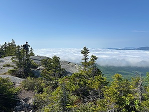
Your Legs Will Hate You, Your Eyes Will Thank You by GrangerGuy The trail connects two nice parking areas on Maine Highway 26 in the town of Newry. From the south end, it climbs aggressively to the summit of Puzzle Mountain, and then works its way north up through lots of ups and downs, arriving at the Appalachian Trail at the summit of Baldpate East Peak. To complete the trail, one follows the AT west back to ME-26. The views from Puzzle and Baldpate are spectacular. Hike Starting from the Mahoosuc Land Trust lot, the south trailhead for the loop, climb on well-constructed and well-maintained but sometimes steep trail almost to the summit of Puzzle Mountain (3133'). The best views are from the shoulder of the mountain, the summit being in the forest. There are great views of the Sunday River Ski Area and Old Speck, a peak on the western half of the loop.
Leaving the high point, the trail descends steeply down the fall line in the midst of a creek bed, or possibly having created it. The next major campsite is Town Corner at 2400', at about 9.5 miles from the start, which has good water. We did not follow the side trail all the way to the main campsite. You will have to see for yourself. From Town Corner, the descent continues to about 1700', then climbs about 300' to the excellent Lane Campsite with a privy, excellent water, and a short spur trail to a very nice waterfall. From Lane Campsite, it is about an 1800' climb in 3.5 miles to the summit of the East Peak of Baldpate, and the intersection with the Appalachian Trail. The views from the top are tremendous! After going over the West Peak of Baldpate, it is 1000' of big bouldery stair steps down to the turnoff to the Baldpate shelter, and then a much easier trek the rest of the way back to the north parking lot. Although the east half of the loop is stated to be 17 miles, our analysis suggests nearly 20. History The Grafton Loop Trail East Half was completed in 2003, principally by the Maine Appalachian Trail Club. Note Grafton Notch is a mountain pass that demarks the northeastern end of the Mahoosuc Range. Check out the Official Route and Triplog. Leave No Trace and +Add a Triplog after your hike to support this local community. One-Way Notice This hike is listed as One-Way. When hiking several trails on a single "hike", log it with a generic name that describes the hike. Then link the trails traveled, check out the example. | |||||||||||||||||||||||||||||||||||||||||||||||||||||||||||||||||||||||||||||||||||||||||


