username
X
password
register
for free!
help
 This is likely a great time to hike this trail!  Check out "Preferred" months below, keep in mind this is an estimate. 
  🔥

Wildcat Hill, AZ

Guide 1 Triplog  0 Topics
  0 of 5  
Fav
Wish
0
details
drive
no permit
forecast
🔥
route  
stats
photos
triplog
topics
location
25 1 0
Statistics
tap row or icons for details
Difficulty 1.5 of 5
Distance Round Trip 0.9 miles
Trailhead Elevation 7,177 feet
Elevation Gain 358 feet
Accumulated Gain 358 feet
Avg Time Round Trip 45 minutes
Kokopelli Seeds 2.69
 Interest Peak
unreported if dogs are allowed
editedit > ops > dogs to adjust
feature photo
Photos Viewed All MineFollowing
Inaugural Calculation on Button Tap!
25  2025-08-08 NitroTheWolf
Author
author avatar Guides 9
Routes 73
Photos 297
Trips 22 map ( 116 miles )
Age 21 Male Gender
Location Scottsdale / Flagstaff
Historical Weather
Trailhead Forecast
Radar Map
Expand Map
Preferred Oct, May, Apr, Sep → 7 AM
Sun  6:03am - 6:51pm
Official Route
 
0 Alternative
 
Historic Fire Perimeteracres
🔥 2019 Boulin Fire4k


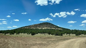
Just another cinder cone
by NitroTheWolf

 Likely In-Season! 
Overview
Nothing special about Wildcat Hill, though you do get a nice view of Sitegrieves Peak from the summit. Other than that, it's a standard, run-of-the-mill cinder cone that is already ubiquitous in Northern Arizona.


Hike
There are two ways to attack Wildcat Hill. The western side, which offers more forgiving slopes and a road halfway to the top, or the north side, which gains 350' vertical gain in 0.15 miles for the masochists.
remove free decal offer
Getting to the western side is easy, just follow Forest Road 115, then turn west on Forest Road 2043 and drive to the base of Wildcat Hill. If you have a vehicle with a short wheelbase and 4WD, you can continue driving up to the southern tip of the hill. Forest Road 2043 is a rough road, so if you don't have at least high clearance, don't even attempt to drive on it. Just park at the junction of 2043 and 115 and start your hike from there. Hiking from the west side is easy, just follow the road up till it ends and head toward the summit following the foot / game trail. Hike down the way you came, and that's it, you've hiked up yet another cinder cone in Arizona.

Northern side now. This way is for the people who want to feel the burn. From Forest Road 115, you gain 350 vertical feet in 0.2 miles. A bit steeper than the west side, and no game trails or roads leading up. Sure, you can hike up in a switchback formation type of way, but at that point, just go around to the west side and go the easy way.

Not much at the summit. You get some views of Sitegrieves Peak and you can sign the summit log if you wish. But other than that, there's not much up here.

2025-08-09 NitroTheWolf


    Check out the Official Route and Triplog.
    Leave No Trace and +Add a Triplog after your hike to support this local community.
    WARNING! Hiking and outdoor related sports can be dangerous. Be responsible and prepare for the trip. Study the area you are entering and plan accordingly. Dress for the current and unexpected weather changes. Take plenty of water. Never go alone. Make an itinerary with your plan(s), route(s), destination(s) and expected return time. Give your itinerary to trusted family and/or friends.

     Permit $$
    None


     Directions
    or
     Road
    FR / Jeep Road - Car possible when dry

    To hike
    From Flagstaff
    Follow I-40 W to Cool Pines Rd in Parks. Take exit 171 from I-40 W: 22 min (24.6 mi)

    Head northwest toward I-17 N: 0.2 mi
    Merge onto I-17 N: 0.1 mi
    Continue onto S Milton Rd: 0.2 mi

    Make a U-turn: 0.2 mi
    Continue onto I-17 S: 0.2 mi
    Take exit 340B to merge onto I-40 W toward Los Angeles: 23.5 mi
    Take exit 171 toward Pittman Valley Rd/Deer Farm Rd: 0.3 mi
    Take N Buggy Wheel Rnch Rd, Forest Service Rd 74, and Forest Service Rd 730 to your destination: 27 min (11.7 mi)

    Turn right onto Cool Pines Rd: 0.1 mi
    Turn left onto N Buggy Wheel Ranch Rd: 3.0 mi
    Continue onto Forest Service Rd 74/Co Rd 74
    Continue to follow Forest Service Rd 74: 4.6 mi
    Turn right onto E Spring Valley Rd: 0.6 mi
    Turn left onto Forest Service Rd 730: 2.3 mi
    Slight left onto Forest Service Rd 115: 0.2 mi
    Slight left
    page created by NitroTheWolf on Aug 08 2025 11:37 pm
     90+° 8am - 6pm kills
    helpcorrectionissue

    end of page marker