Route Editor

| Guide | ♦ | 2 Triplogs | 0 Topics |
details | drive | permit | forecast | route |
stats |
photos | triplogs | topics | location |
| 0 | 2 | 0 |
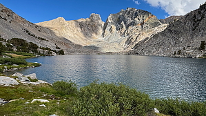
Puff the Magic Dragon by chumley Hike While this isn't an official trail, there's a well-defined route that starts on the PCT just south of the main camping area at Middle Rae Lake, about 150 yards from the sign for the food storage locker there.
After about 0.4 miles, the climb moderates and then drops a bit before passing through a shallow basin and then climbing the last little slope to the banks of the lake. The north shore can be easily traversed for an additional half mile or so with plenty of opportunities for spots to take a break. Views across the lake to the geologically colorful namesake Dragon Peak along with Dragon Tooth and North Dragon Pass make this a worthwhile side trip from the Rae Lakes area. There are no visible use routes beyond the lake, though it appears that ambitious hikers could continue higher in a couple of directions. Most will choose the easy path and follow their path back downhill to Rae Lakes. Camping While it appears that relatively few people camp along this route, there's an impacted site that looks nice on the north side of the outflow creek at the west end of the lake. Other less-impacted possibilities exist at the higher parts of the trail, some with very nice views down to the Rae Lakes. Check out the Official Route and Triplogs. Leave No Trace and +Add a Triplog after your hike to support this local community. | |||||||||||||||||||||||||||||||||||||||||||||||||||||||||||||||||||||||||||||||||||||||||||||