 Route Editor

| Guide | ♦ | 1 Triplog | 0 Topics |
details | drive | no permit | forecast | 🔥 route |
stats |
photos | triplog | topics | location |
| 0 | 1 | 0 |
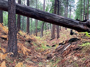
Who Knows? by kingsnake   This is a small canyon on the Rim, between Turkey Pen Ridge and Fred Haught Ridge. Only 2½ miles long, it has two upper branches that both start off FR 719. The branches join after 1¼ miles. Cabin Loop connects the branches. The draw continues for another 1¼ miles, crossing FR 719 (again) before emptying into Bear Canyon ¾ mile downstream of the FR 95 washout. This is a small canyon on the Rim, between Turkey Pen Ridge and Fred Haught Ridge. Only 2½ miles long, it has two upper branches that both start off FR 719. The branches join after 1¼ miles. Cabin Loop connects the branches. The draw continues for another 1¼ miles, crossing FR 719 (again) before emptying into Bear Canyon ¾ mile downstream of the FR 95 washout.A loop of the draw's two upper branches is 2.9 miles, 280 AEG.
I cannot attest to the east branch, but the west branch has no obstacles and would be a good "Intro To Canyon Crawling", even for kids. The off-trail middle section is smooth sailing. The section below FR 719 is rocky, but not bad. If you go all the way to the end, I'd double back at least to FR 719, as looping via Bear Canyon is tangled, rocky, and slow going. Check out the Official Route and Triplog. Leave No Trace and +Add a Triplog after your hike to support this local community. One-Way Notice This hike is listed as One-Way. When hiking several trails on a single "hike", log it with a generic name that describes the hike. Then link the trails traveled, check out the example. | ||||||||||||||||||||||||||||||||||||||||||||||||||||||||||||||||||||||||||||||||||||||||||||||||


