username
X
password
register
for free!
help


Currant - Duckwater Loop, NV

Guide 1 Triplog  0 Topics
  4 of 5  
Fav
Wish
1
NV > Reno
details
drive
no permit
forecast
route  
stats
photos
triplog
topics
location
10 1 0
Statistics
tap row or icons for details
Difficulty 3.5 of 5
Route Finding 2 of 5
Distance Lasso-Loop 10.11 miles
Trailhead Elevation 7,837 feet
Elevation Gain 3,638 feet
Accumulated Gain 4,906 feet
Avg Time Round Trip 10 hours
Kokopelli Seeds 34.64
 Interest Off-Trail Hiking, Seasonal Creek & Peak
 Backpack Possible - Not Popular
feature photo
Photos Viewed All MineFollowing
10  2025-07-06 pseudalpine
Author
author avatar Guides 62
Routes 1,111
Photos 1,287
Trips 1,383 map ( 10,094 miles )
Age Male Gender
Location Arizona
Historical Weather
Trailhead Forecast
Radar Map
Expand Map
Preferred Jun, Jul, Aug, Sep → 6 AM
Seasons   Spring to Autumn
Sun  5:45am - 5:12pm
Official Route & 1 Rt
 
0 Alternative


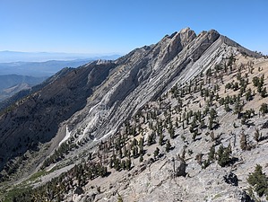
This Ain't No Gooseberry
by pseudalpine

 
Expand MapOverview
A challenging CW lasso loop that tags two >11K peaks in the East Central Great Basin Range of Nevada. Currant Mountain is the highpoint of the White Pine Range, boasting >P4K and dwarfing Duckwater Peak to its north. Indisputably, this hike's culmination is the north/south orientated Stage II sweeping Bristlecone ridge that connects these two stunning summits in the Currant Mountain Wilderness.


Stage I starts west of the creek crossing, following FR-644 west about a half mile, then bears left and attempts to follow an obscure path through the multitude of avy debris. At about mile one, you'll be ascending a more defined drainage, but now dealing with occasional bouldering and thick deadfall. The pitch increases past some eroded and jumbled tarns, eventually becoming even steeper for >1500' of gain over loose limestone talus, some sheer shelves, and more boulders to a saddle south of 11273 T. From here, tracking north to Currant Mountain is straightforward.
remove free decal offer
Apparently, from the mountain top, a direct ramp north is possible to start Stage II, but the official route for this guide doesn't track that possible route. It descends west through some jumbled terrain, then eventually north across some steeply angled talus and in time picks up an obscure trail near 11413 T. Progress north is less intense now as one traverses several saddles and subpeaks. The western slopes below this scenic ridge are mostly blowtorched, with a few areas recently disposed of by an intense fire that had crept/crowned down some of the east-facing slopes.

Duckwater is a rocky and peaceful peak, I'd guess about 3 hours from its more sought-after and prominent prize to the south. Stage III is mainly a steep ~2500' descent, kind of exposed except for some Bristlecone shade, which in due course transects the eastern wilderness boundary at FR-644. Continuing south (right), following the road for a mile and a half, where it then descends more steeply through some broad switchbacks ending up at the spring and creek crossing at ~7800'.

Synopsis
A challenging loop (3.5 of 5.0) in a beautifully rugged landscape that would warrant many return trips to explore other areas in this wild and protected place.

2025-09-23 pseudalpine


    Check out the Official Route and Triplog.
    Leave No Trace and +Add a Triplog after your hike to support this local community.
    WARNING! Hiking and outdoor related sports can be dangerous. Be responsible and prepare for the trip. Study the area you are entering and plan accordingly. Dress for the current and unexpected weather changes. Take plenty of water. Never go alone. Make an itinerary with your plan(s), route(s), destination(s) and expected return time. Give your itinerary to trusted family and/or friends.

     Permit $$
    None


     Directions
    or
     Road
    FR / Jeep Road - Car possible when dry

    To hike
    The closest city is Ely, but one may find themselves south of there at the junction of US 6 (Grand Army of the Republic Hwy) & SR 318. This northern approach accesses NF-405 to White River Campground and the rougher NF-407. Another approach from the south, via Currant Creek Road (MCR 933910), also accesses NF-407. Either approach leads to FR-644, where traveling west allows parking/camping along the two-track, depending on your vehicle's capabilities. Approaching from Austin or Tonopah would also be possible.
    page created by pseudalpine on Sep 23 2025 5:29 pm
    helpcorrectionissue

    end of page marker