Route Editor

| Guide | ♦ | 2 Triplogs | 0 Topics |
details | drive | no permit | forecast | 🔥 route |
stats |
photos | triplogs | topics | location |
| 23 | 2 | 0 |
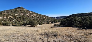
Before you could say Jack Robinson by azbackpackr   This hike winds up through a hollow, or canyon, going into some thick piñon pine forest. Eventually, it heads through the gap between Round Mountain and Flat Top, and completes the loop via the Flat Top Trail. This description assumes you are hiking the loop ↺ counter-clockwise. This hike winds up through a hollow, or canyon, going into some thick piñon pine forest. Eventually, it heads through the gap between Round Mountain and Flat Top, and completes the loop via the Flat Top Trail. This description assumes you are hiking the loop ↺ counter-clockwise.From the parking area, you can follow the fence line and power line due south, and it will quickly connect with the original trail. Finding the original trail in the maze of trails by the entrance is tricky. It's best to just follow the fence line. After a few minutes' hike, the Robinson Hollow Trail merges with the fence line trail. After this merge, follow the most traveled tread. Take a left at the first major fork.
There are a few unmarked "social trails" along the route. Stick to the most beaten path, which is usually the left fork. If you lose the trail tread, go back and find it. The trail is very clear if you stay on it. After following the rocky trail up into and through to the top of the "Hollow", you'll reach an open spot where you can see south to Escudilla Mountain in the distance, and the pointy summit of Flat Top in front of you. Eventually, you'll reach a T junction with a sign. Go LEFT to "Flat Top Mountain" to complete this loop. If you head to the right, it will take you down into Murray Basin. Now you're heading uphill on rocky switchbacks. You'll soon come to another T junction. At this writing, the sign that was there has been removed by dirty rotten vandals. This is the Flat Top Trail, an old dirt road. Turn left to get back to the parking lot. Turn right to get to the summit of Flat Top. I've seen old topo maps that call it "Robertson Hollow." This makes sense because it was named after a local family. I am not sure why it got changed to "Robinson", but sometimes the Forest Service cartographers make errors, and their errors persist until the bitter end of time. That's my opinion, anyway. The trail is mostly used by hikers, but it was built with mountain biking in mind. Only a few local cyclists regularly use it. That's why there are several signs saying things like "More Difficult." It's a bit technical in spots. Not for beginning riders. The trail was designed by a local Forest Service employee who is also a mountain biker. I helped out a little bit as a volunteer, digging new trail, during the summer of 2000, when it was being worked on. He built most of it himself, with the help of a couple of friends. Check out the Official Route and Triplogs. Leave No Trace and +Add a Triplog after your hike to support this local community. | |||||||||||||||||||||||||||||||||||||||||||||||||||||||||||||||||||||||||||||||||||||||||||