Route Editor

| Guide | ♦ | 1 Triplog | 0 Topics |
details | drive | no permit | forecast | route |
stats |
photos | triplog | topics | location |
| 25 | 1 | 0 |
See the Salton Sea by PatrickL Drive The drive to the trailhead requires climbing a short, steep hill about 0.4mi before the parking area. Prepare to add 0.8mi and 100ft of elevation gain to your round-trip mileage if your vehicle cannot negotiate this obstacle.
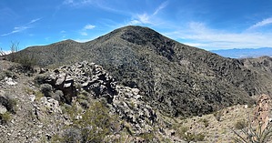
The Orocopia Mountains are the most substantial mountain range overlooking the eastern shores of the Salton Sea. Rising to an elevation of 3,815ft, the highest point provides views of Coachella Valley, Salton Sea, Santa Rosa Mountains, as well as California's portion of the Sonoran Desert. Hike Beginning at the parking area, the route heads south on an old road, which parallels a large wash. At 0.4mi, you'll cross a smaller wash before continuing south once again. The road eventually drifts to the southeast, and at the 1.1mi mark, you'll meander deeper into the hills, eventually reaching an open area around 3000ft. From the 3000ft contour, the trail continues up another hillside where the use-trail is particularly defined. When you reach the top of this hill at 3400ft, you'll descend roughly 100ft, followed by another ascent of 410ft which ends at a small saddle providing your first glimpse of the Salton Sea. The trail continues west toward the Salton Sea before curving back to the south. As you wrap around on the trail, you'll get a good view of the final push to Orocopia Mountain. The consistent ups and downs culminate here at the last saddle at 3460ft. Thus begins the final 350' ascent to the peak. There is a good portion of trail here, though it may be difficult to see on the way up. If all else fails, keep going up and you'll reach the goal. The summit cairn greets you while the broad views of the Salton Sea beckon you further. The surface of the sea is nearly 4000ft below the ground you're standing on. The trail from the peak to the saddle at 3460' is much easier to follow on the way back. Continue retracing your steps back to your vehicle and celebrate your accomplishment. Water Sources No water sources available. Pack in 4 liters of water per person per day. Synopsis This is a great desert hike that rewards you with exceptional views in all directions. The constant ups and downs make it feel endless at times, but it's worth the effort. Check out the Official Route and Triplog. Leave No Trace and +Add a Triplog after your hike to support this local community. | ||||||||||||||||||||||||||||||||||||||||||||||||||||||||||||||||||||||||||||||||||||||||||||