 Route Editor

| Guide | 0 Triplogs | 0 Topics |
details | drive | permit | forecast | route |
stats |
photos | triplogs | topics | location |
| 8 | 0 | 0 |
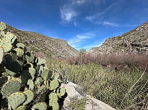
It's easier for a camel to get through the eye of a needle by GrangerGuy   Overview OverviewThe Needle's Eye Wilderness is sandwiched between the Gila River on the south and the San Carlos Reservation on the north. A closed area of the reservation is also on the opposite side of the Gila to the south. A rugged area of BLM land, interspersed with state trust and private land, completes the boundaries to the west. Simply put, this is a tough wilderness to get to. The approach recommended here is wading in along the north side of the river at low water. History The Needle's Eye Wilderness was established in 1990 along with 38 other Arizona wilderness areas through H.R. 2570, sponsored by Morris K. Udall and ushered through the Senate by Dennis DeConcini. The "Needle's Eye" name comes from a narrow canyon along the Gila where the water pours through.
Private land sits astride two of the most obvious access points astride the wilderness: following the river up from AZ77, and along Mescal Creek on the north. Hikers are urged to make friendly contact with landowners before trying these routes. An Arizona State Lands Recreation Permit is required for the access described here. Crossing the river to the San Carlos lands is not allowed. Hike The posted route starts at a practical parking place, which can be accessed with a high clearance vehicle without any challenging four-wheeling required. With more bravery, one can drive the first 3 miles of the route all the way to the river. From the parking spot, follow the road down across the wash, then up to a high point, and then down toward the river. There are good views of the uplifted strata that form the wilderness all along this walk, as well as views into the San Carlos Reservation and up the Gila Canyon. Just before getting to the river, turn left off the main track onto a track that parallels the river. This track is the best route to the edge of the wilderness, and it ends by dissolving into the river at the wilderness boundary. We tried going upstream, keeping our feet dry by pushing through the brush (slow) and climbing around the brush up on the steep bank (scary and dangerous). In the end, it seemed the best approach was to wade the river as close to the north bank as possible, and go as far as you feel like going. We went on a day where the river gauge at Coolidge Dam was reporting 163 CFS. As far as we got, the water stayed below our waist. The wading was not difficult; the bottom is mostly pretty firm and not rocky. I think one could go a lot further than we went, but be prepared to get wet. I think it might be fun to carry or pull a pack raft upstream and float back down. If you do this, don't overshoot the road, as the water gets rough and soon enters private land. Check out the Official Route. Leave No Trace and +Add a Triplog after your hike to support this local community. One-Way Notice This hike is listed as One-Way. When hiking several trails on a single "hike", log it with a generic name that describes the hike. Then link the trails traveled, check out the example. | |||||||||||||||||||||||||||||||||||||||||||||||||||||||||||||||||||||||||||||||||||||||||


