Route Editor

| Guide | ♦ | 32 Triplogs | 0 Topics |
details | drive | no permit | forecast | 🔥 route |
stats |
photos | triplogs | topics | location |
| 114 | 32 | 0 |
Canyons are inherently risky. Flash floods occur without notice on sunny days. Technical skills & surrounding topography knowledge required yet does not eliminate risk.
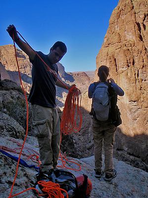
Small fish in a big pond by nonot  Overview OverviewA Class 3AII canyoneering trip in the northern Superstition Mountains with a single rappel of 127 feet. Warning This trip involves rappelling and down-climbing. A full set of technical canyoneering gear is needed, including: helmet, harness, carabiner, and rappelling device. For this trip, add a 150 ft rope (200 ft worked well), AND 150 ft pull cord. Canyoneers must be comfortable with rigging and rappelling single-line if they bring a pull cord instead of a second rope. Furthermore, I recommend each party take along 10 ft of webbing and 1 quick link.
Canyoneering involves slot canyons, and you don't want to be in these places during a flash flood. Check the weather before you depart on your trip, and do not attempt to go if there is any chance of rain. Warning The amount of down-climbing required for this trip is significant. None of the down-climbs on the route I took were difficult (YDS class 2-3 hiking terrain). However, individuals need to be comfortable on the rocks and understand how to cope with exposure. Other individuals have informed me of anchors they created and rappelled off of at some down-climbs in this canyon they were uncomfortable with descending. I did not see any of these anchors, nor did I think any were necessary on the route I took. No two people will likely descend this canyon in exactly the same way, so be prepared if you hit a YDS class 4 drop. History Todd's book derives the canyon name from the fact that it can be completed in a "3 hour tour". If you're lucky, you may meet Ginger or Mary Ann on the way. Before I bought the book, I thought it might have contained rare Gila topminnows, but this is not the case. Hike From the Tortilla TH (at Apache Trail), head up the road to Tortilla TH. At exactly 1 mile, we left the road and began to contour around the hill to our east. The going is fairly easy, and you can pick a good route to avoid the brush. We descended at a convenient spot into the drainage. Continue following the drainage downhill. Unfortunately, the next half mile involves a bit of catclaw, but it is pretty mellow as far as off-trail Supes hiking is concerned and is nearly all avoidable. You pass by some drainages coming in on the right, and I observed one cairn found at the second drainage, indicating there may be an alternate, more-popular route into the canyon bottom. In all reality, you could get here in any of five hundred different ways, so don't experience anticipation paralyzation if you deviate from the course so far. Eventually, the canyon begins to deepen, and you will encounter some easy down-climbs around boulders. After a few easy obstacles, you will encounter the edge of a boulder and look upon a 25-foot drop you can't down-climb. This is the beginning of the tunnel section, and your group will have to work together to find the safe way to descend into and underneath the boulder field. Your party will likely want to take some time to explore and enjoy these tunnels. There are several sections, so after you emerge from the first tunnel, do not think you are done! After a few more tunnels, the canyon begins to get steeper, and you will begin down-climbing a few class 3 boulders. At one spot where you look down at a 25-foot drop with an 18 ft log 2 feet in diameter, I recommend you hug the right wall (LDC) to bypass. Soon, but not too soon, you will reach the major cliff in the canyon, the only rappel. Two bolts are found towards the left edge of a pour-over. This is your anchor for the 127 ft rappel. Gear up here and rig your ropes. The descent is slightly to the right (LDC) and is nicely sloping until the last 40 feet, which transitions to overhanging. After this, you can shed your gear and continue some easy and fun down-climbing until you, too soon, reach Fish Creek. Turn left and reach your shuttle vehicle in 10-15 minutes or spend some time exploring. Water sources Fish Creek generally has water year-round. Bring a filter. The water surfaces only in sections during dry conditions, so you may have to hunt for a good source. Camping At large camping sites can be found throughout Fish Creek. Some are better than others. I'd recommend you obtain some distance from the Apache Trail to enhance your experience; otherwise, you may be disappointed with the traffic (human and vehicular.) Please pack out everything you bring in (including all trash) and help to preserve this beautiful area for others to enjoy. Also, be aware that after light to moderate rains, the creek can become a life-threatening torrent of water, so plan ahead and read the weather report. Combination canyon trips A strong party may want to attempt both Minnow and Apache Trail Canyon with an early start. I would not recommend attempting to do both Tango and Minnow on a single day. Terminology I am referencing both the American Canyoneering Association (ACA) Canyon Rating System and the Yosemite Decimal System (YDS) Terrain Rating System within this hike description. The ACA canyon rating system is explained in the canyoneering rating on the top left of the page. Briefly, the YDS rating system is as follows: YDS Class 1 Hiking/walking YDS Class 2 Occasional scrambling, some use of hands YDS Class 3 Climbing/scrambling with use of hands required for balance, minimal to moderate exposure YDS Class 4 Intermediate climbing with moderate to significant exposure, most will want a belay, hand use required to pull yourself upwards, falls would be life-threatening to fatal YDS Class 5 Vertical climbing, ascent by means of hands and feet, rope and climbing gear required for protection ("Sport climbing" and "Trad climbing") YDS Class 6 Vertical climbing, ascent by means relying solely on rope and climbing gear ("Aid climbing") Check out the Official Route and Triplogs. Leave No Trace and +Add a Triplog after your canyon trip to support this local community. | ||||||||||||||||||||||||||||||||||||||||||||||||||||||||||||||||||||||||||||||||||||||||||||||||||||||||||||||||||||||