Route Editor

| Guide | ♦ | 13 Triplogs | 0 Topics |
details | drive | no permit | forecast | 🔥 route |
stats |
photos | triplogs | topics | location |
| 227 | 13 | 0 |
Canyons are inherently risky. Flash floods occur without notice on sunny days. Technical skills & surrounding topography knowledge required yet does not eliminate risk.
Footloose? by nonot  Overview OverviewA class 3AIII technical canyoneering trip in the northern Superstition Mountains. Warning This trip involves rappelling and down-climbing. A full set of technical canyoneering gear is needed, including: HELMET, harness, carabiner, and rappelling device. For this trip, add a GPS, helmet, a 200 ft rope, helmet, and a 60 ft rope. Furthermore, I recommend each party take along 80 ft of webbing, 40ft accessory cord, 7 quick links, and an extra few carabiners. I do not recommend this trip for beginning canyoneers or canyonettes. P.S. Everyone wearing a helmet saved us an otherwise ugly day, buy and wear a helmet!
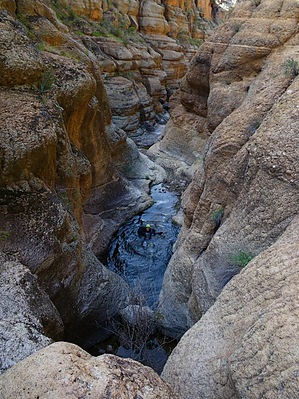
Canyoneering involves slot canyons, and you don't want to be in these places during a flash flood. Check the weather before you depart on your trip, and do not attempt to go if there is any chance of rain. Warning This trip is rated a 5 in navigational difficulty. Horse Mesa is full of indistinct drainages running every which way. I recommend that you make use of the GPS route I will submit. Furthermore, to avoid the possibility of having to make tough choices in the dark, I recommend you get an early start. Warning This canyon has the potential to hold a good deal of water. This description was written following a severe drought when there was still a decent amount of cold water (!) in the canyon, but not an overwhelming quantity. Your experience may vary! Warranty void upon opening, made in China, not for consumption by people under 12 or pregnant... History Attempting to canyoneer Tango Canyon in late 2009, a group reported they found it extremely difficult and lacking anchors. However, my descent of Tango did not find what they reported. Based on the geography and aided by a youtube video, I reconstructed what I believed to be their route. Intrigued, I loaded up with way too much gear and tricked an unsuspecting friend into joining me on this adventure. :D Interestingly, this canyon had very aged webbing, indicating that the first descent may have been 5-10 years ago (or more). Naming Information Sierra is military phonetic for the letter "S". Tango is military phonetic for the letter "T". Sierra Canyon comes right before Tango Canyon in the geography of Horse Mesa on your approach; hence the name is appropriate and fits the theme. The letter "S" in and of itself has some additional significance. Foreword: This description for Sierra Canyon will have sections that read very similar to the Tango Canyon description as both of these trips have similar approaches and returns. Hike From the pullout on the Apache Trail, head into lower Fish Creek and begin rock-hopping downstream. Keep track of your distance as you are looking for the 1st major drainage coming down into Fish Creek from your right at 0.5 miles. Turn right and climb up the west slope of this drainage, trying to stay near the ridge that runs along the west side. You will pass by a rock formation that some say resembles a ship's bow. Past this rock formation, continue climbing up the canyon's left side until you reach a reasonably flat saddle. Do NOT wait too long to make the climb assuming you can use the slot-like drainage you see ahead of you on your left. You need to summit before reaching that drainage. Once on top of the Horse Mesa flats, take a break to catch your breath. You are done with the most demanding part physically, but not navigational! From this point, head west and slightly north. Get on the flat plain and contour your way to the head of the next canyon so that you can get up the 30 ft wall without difficulty. After getting up the wall, contour 100 yards around on the flat part of the ridge to your south, then west, and then where you cliff out, head north. Climb up about 60 ft to your northwest to obtain a saddle to the 2nd major drainage into Fish Creek. This 2nd drainage is the headwaters of Sierra Canyon. Those continuing to Tango will descend into but eventually leave Sierra Canyon. However, you will want to stay in the drainage and continue downstream. Several minor drainages will appear on your right. Observe them but continue heading downhill. Some boulder hopping will be required in several places. You may see some cattails, which is a good sign you're in the right place. Avoid the brush as best you can. The first obstacle that you will encounter is a 15 ft drop over a chockstone into a pool of water. You will want to bypass on canyon left. Continue bouldering your way downstream, and there is an enormous boulder chock-stone you will likely climb under. The canyon begins to deepen and presents some views that encourage you to keep going!
Water sources There were quite a few potholes found in Sierra Canyon, but nothing I would consider drinking in a non-survival situation, so bring at least 3-4 liters. Lower Fish creek will have some water. Depending on the season, Fish Creek could also be flowing strong. However, after four months with almost no rain, only a few isolated pools that looked moderately decent were observed on this trip. You would need a filter. Camping Although I consider it unlikely, participants on this trip could dry camp anywhere on the Horse Mesa flats, as well as the ample at-large campsites in portions of Lower Fish Creek. A few overused campsites are found very close to the car spot. Check out the Official Route and Triplogs. Leave No Trace and +Add a Triplog after your canyon trip to support this local community. | |||||||||||||||||||||||||||||||||||||||||||||||||||||||||||||||||||||||||||||||||||||||||||||||||||||||||