 Route Editor

| Guide | ♦ | 90 Triplogs | 6 Topics |
details | drive | no permit | forecast | 🔥 route |
stats |
photos | triplogs | topics | location |
| 915 | 90 | 6 |
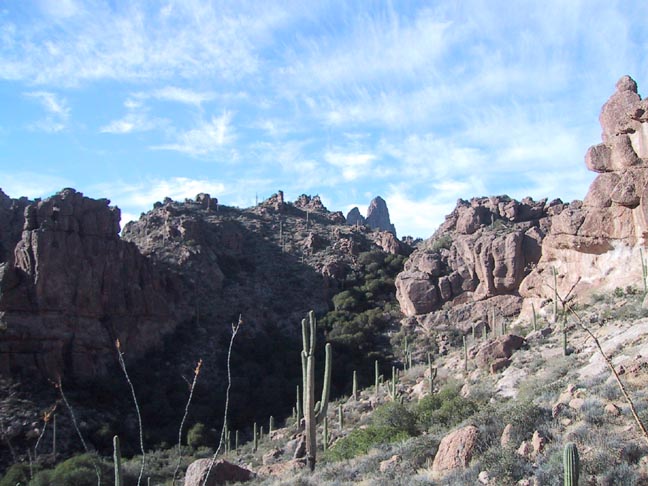
A Master Search by Fritzski  This out-and-back hike begins at the Peralta trailhead and constitutes the shortest route to Charlebois Spring and the home of the famous "Master Map". From the trailhead, you follow the Bluff Spring trail to its intersection with the Dutchman Trail which you then follow north all the way to Charlebois Springs. This out-and-back hike begins at the Peralta trailhead and constitutes the shortest route to Charlebois Spring and the home of the famous "Master Map". From the trailhead, you follow the Bluff Spring trail to its intersection with the Dutchman Trail which you then follow north all the way to Charlebois Springs.I will begin this description from the Bluff Spring / Terrapin Trail intersection which is 2.25 miles in. For details up to that point, please refer to the Bluff SpringTrail #235 or Needle Canyon Loops descriptions. I will take time to mention, however, that the views on Bluff Springs Tr. just prior to Terrapin Tr. looking NW toward Upper Barks Canyon are always exceptional.
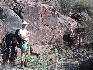
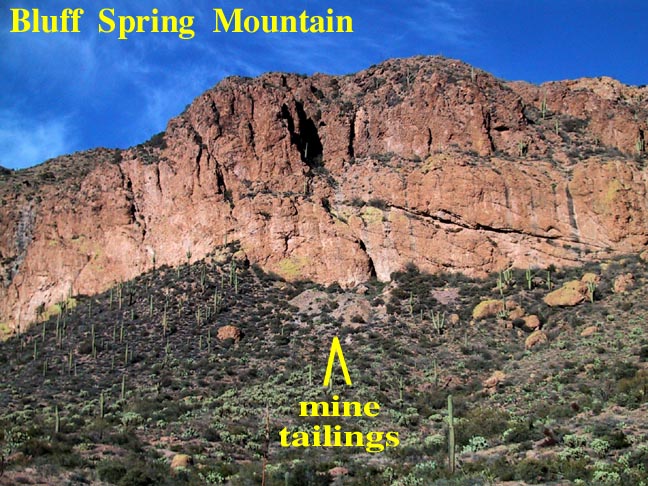
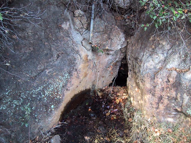
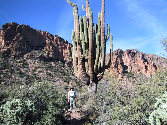
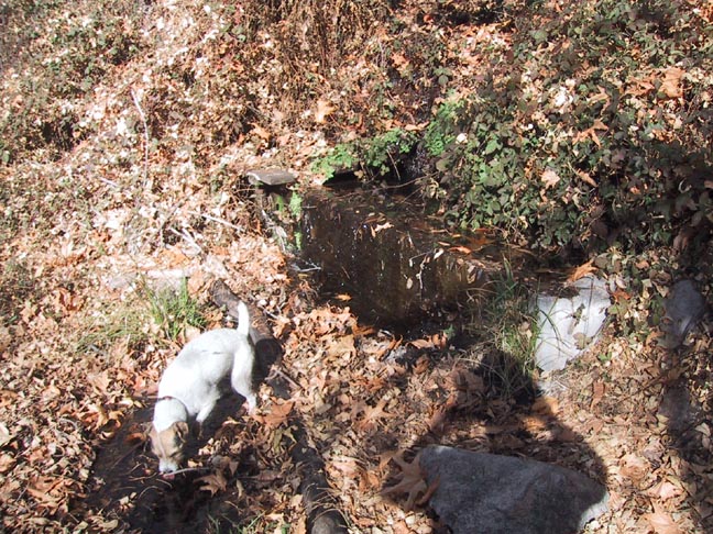
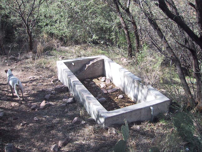
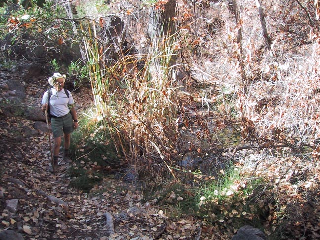
I was fortunate to be hiking this day with my good friend and Forest Ranger Lou Bruneau, and one of our "missions" was to check the status of all the springs along the way for the Forest Service. The first spring you will encounter is Bluff Spring (@3.5mi) which is located a short distance after turning north on the Dutchman Trail. Look for a "use" trail that goes left up into the first ravine on the east face of Bluff Spring Mtn. Although concealed fairly deep in the trees, it is easy to find and for the most water go just beyond the first pipe to the second, which is flowing at about a quart a minute. At about the 4.25mi point the trail turns westerly and begins a bit steeper descent. Look ahead for the famed "50 armed cactus" (we didn't count:) at the 4.5mi. From a distance, this giant saguaro doesn't look all that impressive, but up close it is a true behemoth. It is evidently listed on the National Register as one of the largest on record. Personally, I think the one on Boulder Canyon Tr. just south of the Second Water Tr. intersection gives it a run for the money. As you continue your steady descent into LaBarge Canyon you will come to the Red Tanks Tr. intersection and what I considered to be the prettiest spot on the hike. The riparian area is very lush with large Cottonwoods and Sycamores lining LaBarge Creek. Finding LaBarge Spring can be a little tricky. Follow the Red Tanks Tr. east a short distance till it merges with the creek bed, look for a giant Sycamore, follow the creek bed about fifty more yards and look for a ledge on the opposite (north) bank with a trail worn in the dark soil. At the top of the ledge is a log, which makes for good seating in this picturesque little rest spot. The spring itself is located about twenty feet away to the left, just beyond the fallen tree over the path. It was flowing nicely into a small concrete retention box where the clear water was excellent for filtering. Continuing north toward Music Canyon, you will go through some nice shady areas of Hackberry trees along the trail. It won't be long till you reach the intersection with Peters Tr. which appeared fairly faint and under-used. A short distance ahead is a flat area with many well-used clearings/camping areas at the foot of Charlebois Canyon. A well-used path heads up the canyon toward the spring itself. Along the way, you'll pass a concrete cattle trough once fed by the spring. The "Hiker's Guide to the Superstition Wilderness" describes an inscription on the tank reading "1937". If you look closely you will see that the tank has been rebuilt out of fairly new concrete with just one partial side of the old material remaining. It is my guess that this has been done since the time of Carlson's writing and therefore the inscription no longer exists. Continuing up the canyon you will begin to encounter numerous pools of flowing water amongst the thickening vegetation and boulders. It was now time to turn back, but not before finding the much-ballyhooed Master Map. Whether the inscriptions on this rock face were pictographic directions made by Mexican miners well over a century ago possibly leading to a lost mine as some would hope, or merely designs of unknown meaning left by ancient native Americans has never been determined. Although this site is touted by some sources as "easy to find", I would have to disagree. Using two independent sources of directions, which both turned out to be of marginal value, our search of the area came up frustratingly empty-handed. It was only after we gave up the search and were attempting to make our way back to the main trail that we more or less stumbled on to it. Contrary to some reports, the rock is not obscured by bushes, but sits pretty much in plain sight with the very old Forest Service sign still intact, but barely legible. In reality, the Master Map or "Inscription Rock" itself is not all that spectacular. But because the real reward lay not in the objective, but rather in the search itself, I will refrain from giving away its location so as not to ruin it for those who relish an enjoyable challenge. Good luck and have fun! Check out the Official Route and Triplogs. Leave No Trace and +Add a Triplog after your hike to support this local community. | ||||||||||||||||||||||||||||||||||||||||||||||||||||||||||||||||||||||||||||||||||||||||||||||||||||||||||||||||||||||||||||||||||||||||||||||||||||||||||||||||||||||||||||||||||||||||||||||||||||||||||||||||


