Route Editor

| Guide | ♦ | 38 Triplogs | 0 Topics |
details | drive | no permit | forecast | 🔥 route |
stats |
photos | triplogs | topics | location |
| 215 | 38 | 0 |
Canyons are inherently risky. Flash floods occur without notice on sunny days. Technical skills & surrounding topography knowledge required yet does not eliminate risk.
No Place Like Home by AZLOT69  History HistoryWith all the legends and lore about gold in and about the Superstitions, since 1893, only about twelve mines produced any quantity of gold. All twelve of these were sandwiched in the area between the Superstitions and the Goldfields and includes the Palmer mine. These gold strikes were located on documented geologic fault lines that basically run in a north-south direction on either side of State Route 88 in the Goldfield area. As you get away from these fault lines, you have little chance of finding a gold vein but as a prospector. Why let facts stand in your way. Overview The trail starts at the northernmost part of these documented faults, circles around a butte, and dips into a secluded canyon that was long ago abandoned by prospectors. The canyon ends above the Willow Springs Basin. The wash has several pockets that hold water for long periods, making this canyon regularly visited by wildlife. The loop is completed by returning via upper Willow Springs Canyon.
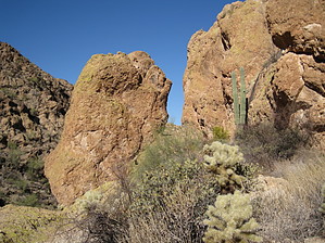
The hike is described in a clockwise direction and would be very hard to find traveling in a counterclockwise direction on the first try unless you follow the GPS route. From Willow Springs Trailhead, take the jeep road two-tenths of a mile. When it dips into the wash, take the left fork and go left in the wash, immediately turning right out of the wash up the hill. At the top of the hill, you pass thru an old fence line. Stay right at the next turn and continue on this old jeep road to its end at six-tenths of a mile from the trailhead. A single-track trail continues from here, marked by the cairn at the west end of the old jeep trail. The trail heads down to a wash where the trail goes left, following the bank of the wash on the right side. Undoubtedly, you will be tempted to climb on the many colorful rock structures in this area, and don't forget to look behind and catch a nice angle of Weavers Needle. The trail comes to a slick rock area where the trail crosses to the wash's left side. In about a hundred yards, there is a junction. Continue straight and get down in the slick rock wash on your right. When the slick rock wash veers left, go right, climbing out of the wash and heading towards a slot between two rock features. There are sheer drop-offs to your left. Go thru the slot between the rocks and down the fairly steep ramp to the wash. Be cautious of your footing on the ramp as there are some loose rocks, and you could turn this into a slide. Down in the wash, there are steep walls on both sides of the canyon. Watch for evidence of small prospects dug near the canyon walls on either side. There are plenty of interesting rocks to rummage thru. Rocks laced with crystal and quartz are common. Carefully cross an old barbed wire fence and start downstream in the wash bottom, rock hopping for about a hundred feet. Then work your way up the left bank and find the trail. There is plenty of evidence of animal activity in the area. The trail continues along the left bank for about a quarter-mile, then switches over to the right side and hugs a sheer cliff for a distance. As the canyon levels off, the trail shifts back and forth across the wash. Take the best available path staying close to the wash. The wash comes to an end at a fifteen-foot waterfall with a natural tank at its base. You can't climb down the waterfall without a rope. Bypass it by going up the embankment on the right up to the ridge and go left following the ridge to the end, where a down climb brings you to the flatland of Willow Springs Basin. Take the easiest path to the north and join up with the jeep trail in Willow Springs Basin. Once at the jeep trail, turn right. The jeep trail turns left out of the wash. Continue straight, and the jeep trail rejoins you in a short distance. A short while later, the jeep trail turns left out of the wash again. It repeats this another time. Stay in the wash and continue straight and into Willow Springs Canyon Upper. You will have to do a little light boulder climbing thru this slotted area. Once above the slots, work over to the right bank where you will find dozens of metates as well an old pipeline from ranchers that once occupied the area. Continue upstream to Willow Spring, which generally has water year-round marked by Cottonwood trees. The canyon soon rejoins the jeep trail. Continue on the jeep trail back to the trailhead. Check out the Official Route and Triplogs. Leave No Trace and +Add a Triplog after your canyon trip to support this local community. | ||||||||||||||||||||||||||||||||||||||||||||||||||||||||||||||||||||||||||||||||||||||||||||||||||||||||||||||||||||||||||||||||||||||||||||||||||||||||||||||||||||||||||||||||||||||||||||||||||||||||||||||||||