Route Editor

| Guide | ♦ | 8 Triplogs | 0 Topics |
details | drive | no permit | forecast | 🔥 route |
stats |
photos | triplogs | topics | location |
| 170 | 8 | 0 |
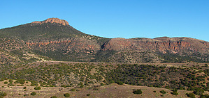
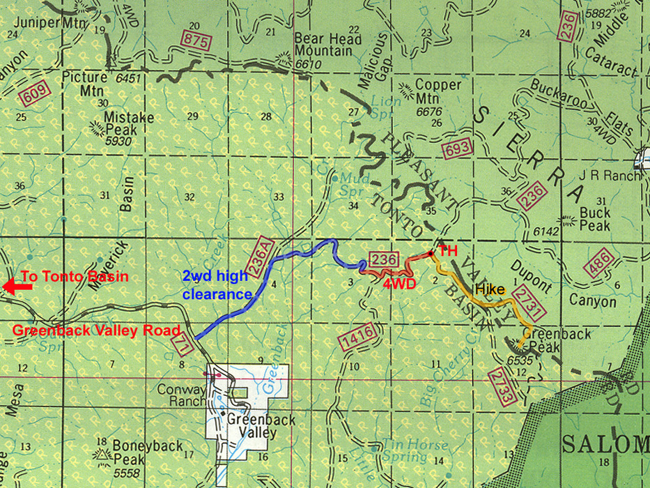
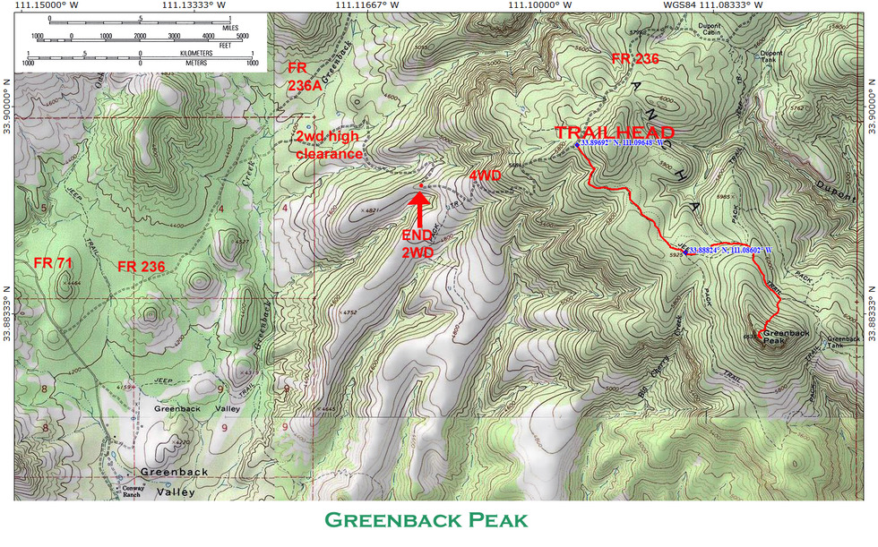
Well worth a fistful of greenbacks by PrestonSands   Overview OverviewIn Arizona's rugged Sierra Ancha, Greenback Peak is an ideal destination for those who seek adventure and solitude. Those who reach its 6535-foot summit are greeted with a 360-degree view of the Sierra Ancha. The journey to Greenback Peak involves a four-wheel-drive road, an ATV (all-terrain/off-road vehicle) trail, and an off-trail bushwhack. There is no formal "trailhead" for this hike, so your starting point will depend on your preferences and your vehicle (and how much abuse you are willing to put your vehicle through). This guide begins where Forest Road 2731/2733 (the previously mentioned ATV trail) departs from Forest Road 236 (four-wheel drive). Those without four-wheel drive will have to hike the four-wheel-drive portion of Forest Road 236, making for a longer hike than is listed in the statistics. Please see the directions for detailed road information.
Hike Four and a half miles up Forest Road 236 from Forest Road 71/Greenback Valley Road lies the unsigned junction of Forest Road 236 and Forest Road 2731/2733 (GPS coordinates 33.89692 N, 111.09648 W). Begin hiking southeast up Forest Road 2731/2733 (an ATV trail, in actuality) as it charges through the chaparral brush. The ATV trail skirts a brushy hillside and reaches a broad mesa covered in dense pinion pines and alligator junipers at the half-mile point. Greenback Peak's rocky head comes into view, and the ATV trail rambles across the mesa towards it in a southeasterly direction. One mile in, the ATV trail breaks into a grassy clearing and crosses through a gate in a barbed-wire fence. A few hundred feet beyond the gate, the ATV trail divides (33.88824 N, 111.08602 W). Go left onto FR 2731 (another unsigned ATV trail). This route avoids the cliffs along Greenback Peak's southern and western edges. The hike along FR 2731 travels east into the pine forest, rounding Greenback Peak's north ridge. Once around, the ATV trail turns southeast again, along the north slope of Greenback Peak itself. You'll want to leave the ATV trail somewhere in this vicinity and climb the peak's north slope. Climbing about 500 feet through a mix of ponderosa pine and manzanita, the off-trail jaunt to the summit is relatively easy, albeit time-consuming. Arriving atop Greenback Peak, the forest gives way to brush, cliffs, tilted beds of colorful Troy Quartzite, and something else that is unmistakable and very special. An enormous boulder crowned with a cairn marks the summit and provides an outstanding 360-degree view. Flat bedrock along the cliff edge makes a great spot to sit and enjoy the sweeping view that stretches from the Pinal Mountains to the Mogollon Rim. Walk along the cliff to the south edge of Greenback for a peek into Salome Canyon. For a longer return hike, there is the option to continue south on FR 2731 and cut across the south slope of Greenback Peak to connect with FR 2733. Gate Policy: If a gate is closed upon arrival, leave it closed after you go through. If it is open, leave it open. Leaving a closed gate open may put cattle in danger. Closing an open gate may cut them off from water. Please be respectful, leave gates as found. The exception is signage on the gate directing you otherwise.
Check out the Official Route and Triplogs. Leave No Trace and +Add a Triplog after your hike to support this local community. | |||||||||||||||||||||||||||||||||||||||||||||||||||||||||||||||||||||||||||||||||||||||||||||||||||||||||||||||||||||||||||||||||||||||||||||||||||||||||||||||||||||||||||||||||||||||||||||||||