 Route Editor

| Guide | ♦ | 4 Triplogs | 0 Topics |
details | drive | no permit | forecast | 🔥 route |
stats |
photos | triplogs | topics | location |
| 22 | 4 | 0 |
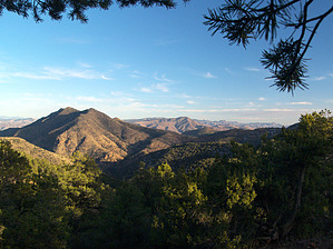
delicious fryes by PrestonSands   Overview OverviewThe Frye Trail #12 serves as a connector route in the Granville area trail system, in the mountains north of Morenci, Arizona. In addition to being a part of the Grand Enchantment Trail, the scenic Frye Trail offers distant mountain views, cool maple-filled canyons, and opportunities for secluded backpacking. The connecting routes of the Pinal, Granville, and H.L. Canyon Trails create multiple opportunities for a loop hike. The Frye Trail is accessible on the south end by a 0.85-mile long high clearance road, and on the north end by a 1.3-mile hike on the H.L. Canyon Trail. Hike The south (main) trailhead for the Frye Trail is located at a dirt parking area where the trailhead access road forks, just inside Forest Service land. A trail sign marks the fork. Follow the left fork, which curves west and quickly comes to another sign for the Frye Trail. The Frye Trail departs from the north side of the road at this point (33.18028 N, 109.35751 W), heading west.
Climbing out of the Cave Creek drainage, the trail crests a low saddle and enters the gentler terrain of upper Fry Canyon. Here it meets the Pinal Trail #713 on a hillside at around 1.5 miles. A sign in a tree marks the junction (33.19376 N, 109.36061 W). Just past the junction, the Frye Trail dips into Frye Canyon, where pines, bigtooth maples, an old cabin site, and water from nearby Fry Spring make for an attractive backpacking destination. Fry Spring, which appears to be perennial, is tucked into a short little side drainage that branches north from where the Frye Trail crosses its namesake creek. The approximate location of the spring: 33.19601 N, 109.3612 W. From where it drops into Frye Creek, the Frye Trail heads east along the creek bed for a few hundred yards, before climbing the north bank. The hike then levels out somewhat, roughly following the 6400-foot contour through a forest of mature pinyon pines. The trail gets a bit scarce as it contours around a couple of ridges but never disappears entirely. At 2.5 miles, the Frye Trail meets the Granville Trail #572 at another signed junction in a ridge top saddle (33.20152 N, 109.35593 W). At this point, the Frye Trail begins its descent into Sardine Canyon. The Frye Trail first heads north, following a ridgeline down from the saddle, then drops off of the west side of the ridge to weave in and out of maple-filled draws, ultimately reaching the floor of Sardine Canyon at 3.25 miles. The trail gets a bit vague as it leaves the canyon floor to climb a brushy hillside, so watch carefully for cairns and marker tape. Following a 200-foot climb to a little brush-covered bench at the 6400 contour, the Frye Trail comes to an end upon meeting the H.L. Canyon Trail #11, at a signed junction at 3.5 miles (33.20927 N, 109.35956 W). If you continue west from the H.L. Canyon Trail junction, it is a 1.3-mile hike up Sardine Canyon on the H.L. Canyon Trail to the Sardine Saddle picnic area on U.S. Highway 191. Another option is a loop hike using the Pinal, Granville, or H.L. Canyon Trails. Check out the Official Route and Triplogs. Leave No Trace and +Add a Triplog after your hike to support this local community. One-Way Notice This hike is listed as One-Way. When hiking several trails on a single "hike", log it with a generic name that describes the hike. Then link the trails traveled, check out the example. | ||||||||||||||||||||||||||||||||||||||||||||||||||||||||||||||||||||||||||||||||||||||||||||||


