Overview
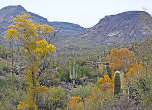
This trail is in a riparian area along Cave Creek within the Jewel of the Creek Preserve at Spur Cross Ranch Conservation Area. It is very lush along the creek with willows, walnut trees, alders, and other trees. There is also a mesquite bosque.
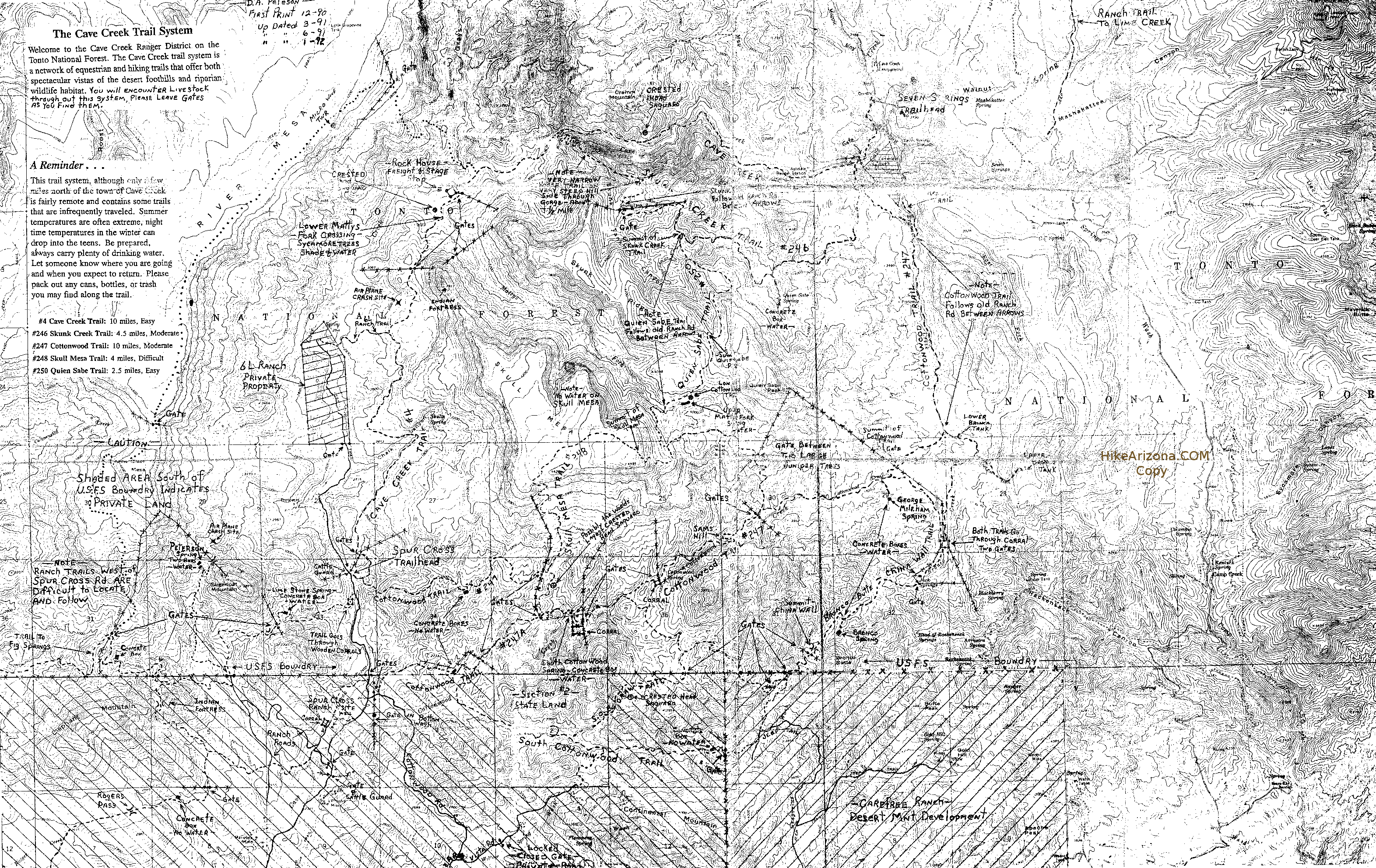
You can connect to this trail via Spur Cross Trail and Tortuga Trail so that you can experience desert and creek hiking. For example, you can leave from the Spur Cross Trailhead and head west up the Tortuga. You can hook up with the Dragonfly Trail by taking the first intersection and continue south on the Spur Cross Trail or continue on the Tortuga Trail for about another mile to the second intersection (at the top of the rugged hill just before the Elephant Mountain junction) where you will head east to the junction with the Spur Cross and Dragonfly trail.
Once you get to the creek, you come to another junction where the Dragonfly Trail goes north and south. You can go either way. If you go south, the trail will cross the creek, and you will come to a u-turn that takes you above the creek and then back down to the creek. You will come across an interesting rocky formation and continue by the creek for a while until you come to another intersection; stay to the east and head up the hill where you will come to the Jewel of the Creek Preserve sign and parking area alongside Spur Cross Road. The Spur Cross Stables are across the road. The parking area for the Spur Cross Trailhead is to the north of that.
If you go north at the junction, you will be walking next to Cave Creek. It is very scenic, as you walk through many different eco-areas, including giant saguaros and a rock area including a small mine shaft that goes back about 10 to 12 feet. You continue along and will walk under a short extended tree branch and out again alongside the creek bed with the cottonwoods and other trees. You are hooking up with the Jewel of the Creek loop trail, where there are a couple of different places to cross over to the creek's east side. I prefer going to the far north side where you can cross the creek. There will be rocks to guide you at the turn spot as you turn east to cross the creek. However, if the Creek is running, this may alter your plans as to where to cross the creek.
Once you have crossed the creek, you will go through a slightly burned area and come to the intersection where the trail goes up the hill. Make the u-turn here to head north back to the trailhead.
WARNING! Hiking and outdoor related sports can be dangerous. Be responsible and prepare for the trip. Study the area you are entering and plan accordingly. Dress for the current and unexpected weather changes. Take plenty of water. Never go alone. Make an itinerary with your plan(s), route(s), destination(s) and expected return time. Give your itinerary to trusted family and/or friends.
Permit $$
Spur Cross Conservation Area $5 per person
Directions
Road
FR / Dirt Road / Gravel - Car Okay
To Jewel - Dragonfly Trailhead I-17 North & Exit 233, which is SR-74 the Carefree Highway. Head east on Carefree Highway 9.9 miles to Cave Creek Road. Head North on Cave Creek Road 2.6 miles to Spur Cross Ranch Road. The road jogs a bit here but you go 4.0 miles to the parking lot.
It is a well-graded dirt road. As it nears the parking area, the road leads past a large green house, through a tall gatepost and past a corral. There is a large signed parking area. Along the road about 75 yards northeast of the parking area, there is a self-pay station and a small informational kiosk with rudimentary maps. Pay the fee and carry the stub with you.
Above is for the main parking. Dragonfly / Jewel of the Preserve is 0.2 mi BEFORE the main lot. HAZ is unsure if there is a pay station at this trailhead. You do need a permit.
From PHX (I-10 & AZ-51) 35.8 mi - about 57 mins From TUC (Jct 1-10 & Grant) 144 mi - about 2 hours 26 mins From FLG (Jct I-17 & I-40) 133 mi - about 2 hours 10 mins
 Route Editor


 Overview