Route Editor

| Guide | ♦ | 1 Triplog | 0 Topics |
details | drive | no permit | forecast | map |
stats |
photos | triplog | topics | location |
| 14 | 1 | 0 |
Canyons are inherently risky. Flash floods occur without notice on sunny days. Technical skills & surrounding topography knowledge required yet does not eliminate risk.
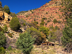
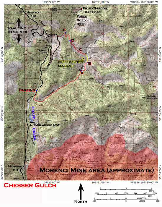
big grins from the Chesser Cougar by PrestonSands   Overview OverviewChesser Gulch is an interesting and scenic side canyon that branches off from upper Chase Creek canyon, in the mountains north of Morenci, Arizona. This off-trail hike can be done as an easy out and back, or as a longer and more difficult loop using U.S. Highway 191 as the return route. The upper end of Chesser Gulch connects with Forest Road 8375 (the trailhead access road for the Frye Trail #12/Grand Enchantment Trail). The main item of interest on this hike, aside from the scenery, is an old line shack cabin. The most convenient place to begin hiking is at the mouth of Chesser Gulch, along highway 191. Chesser Gulch is the first canyon on the east side of the highway beyond the Morenci mining operation and the Chase Creek dam. This is also where highway 191 crosses from the west side to the east side of Chase Creek. Parking is available along the west side of the highway, just past the Chase Creek crossing. A chainlink fence partially blocks the entrance to Chesser Gulch, but it can be bypassed on the north side. There are not any "no trespassing" signs posted; the fence just appears to mark the northern boundary of the Morenci mine property. Please see the included topo map for clarification, and for the reference points included in this description.
Water Chesser Gulch is dry most of the year, but there did appear to be a spring in the creek bed, about one mile in from the highway. Hike Bypass the fence at the mouth of Chesser Gulch, and begin hiking up its rocky streambed. The hike up the gulch basically follows the creek bed through the narrow canyon, although a few surviving stretches of an ancient road do allow for short bypasses of the creek bottom. The canyon sides are loaded with pinyon pine and Arizona cypress, while the floor of Chesser Gulch is lined with sycamore and mature Emory oak. Bluffs in varying shades of red, brown, and buff poke out from the greenery above. At around 1.2 miles Chesser Gulch widens slightly, and a dilapidated line shack cabin (A) comes into view, in an open area next to an old corral. Junk lies scattered both inside and outside of the cabin. For those not looking to get into bushwhacking and route finding, this is a good turnaround point. If you choose to continue... Just beyond the cabin, a side canyon comes down from the east, and Chesser Gulch turns north. Pinal Point and surrounding lesser peaks now come into view. Chesser Gulch will soon get rougher and choked up with brush. Following the old roadbed where possible becomes the easier option. A short ways past the turn to the north, the old roadbed climbs the east bank and comes to an end (B) at a little flat spot shaded by oak trees overlooking Chesser Gulch. This little flat would make a decent campsite. Before you to the north, two more side canyons join Chesser Gulch from the east. Get your bearings, and head for the ridge between Chesser Gulch (far left canyon) and the middle canyon. With a bit of luck, you can pick up another old overgrown roadbed (C) that runs along the east wall of upper Chesser Gulch, at roughly the 5700-foot contour. This second roadbed eventually deposits itself into the narrow creek bed of Chesser Gulch to follow it up canyon. At about the 5800 foot contour, Chesser Gulch forks (D). Stay in the right fork, and continue to follow the old roadbed, which is very faint in this area. The roadbed soon breaks free from the confines of the canyon and makes two broad switchbacks through a field of catclaw mimosa. After the second switchback, the ancient roadbed becomes an ATV trail, and suddenly terminates at Forest Road 8375 at the 6000 foot contour (E) (33.17284 N, 109.36178 W). If you have made it this far, you'll likely want to take an easier way back to your vehicle. That easier way is a left turn onto Forest Road 8375, which brings you back to highway 191 in less than a quarter-mile (turn left). A couple of miles of easy highway walking will bring you back to the mouth of Chesser Gulch. Along the way, you'll get to enjoy scenic Chase Creek canyon, a natural arch, and high ridges of reddish rock towering high above the highway.
Check out the Triplog. Leave No Trace and +Add a Triplog after your canyon trip to support this local community. | |||||||||||||||||||||||||||||||||||||||||||||||||||||||||||||||||||||||||||||||||||||||||||||