 Route Editor

| Guide | ♦ | 104 Triplogs | 0 Topics |
details | drive | no permit | forecast | route |
stats |
photos | triplogs | topics | location |
| 400 | 104 | 0 |
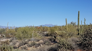
Wild Horse to Lead by alexandy  AKA - Lead Trail AKA - Lead TrailThe Wild Horse Trail is within the Tonto National Forest. It is an unofficial/social multi-purpose, East-West trail, bounded by the Usery Mountains on the South and the Salt River on the North. Hike The eastern end starts at a parking area off Usery Pass Road and ends at the Twisted Sister Trail intersection, in the Hawes Trail System at the western end. An additional 0.8 mile can be added to the trail by starting at another parking area on Usery Pass Road located at 33 30.298, -111 37.041, and heading in a northerly direction until location 33 30.969N, -111 37.219W is reached.
I could not find any information about the origin of the trail's name, Wild Horse. However, while hiking the trail, I did see three wild horses. I have also seen documents and maps naming the trail as the "Lead Trail" This makes sense as the eastern part of the trail goes across a pit that was once an NRA shooting range. While hiking, I came across two lead "miners" who had several buckets full of bullets and shot. Although there are "No Shooting" signs in the area, I saw and picked up about 50 spent shotgun shells with little signs of weathering. Check out the Official Route and Triplogs. Leave No Trace and +Add a Triplog after your hike to support this local community. One-Way Notice This hike is listed as One-Way. When hiking several trails on a single "hike", log it with a generic name that describes the hike. Then link the trails traveled, check out the example. | |||||||||||||||||||||||||||||||||||||||||||||||||||||||||||||||||||||||||||||||||||||||||||||||||||||||||||||||||||||||||||||||||||||||||||||||||||||||||||||||||||||||||||||||||||||||||


