Overview
If you've ever driven between Tucson and Phoenix, you might have noticed a jagged-looking peak southwest of Picacho Peak. This is Ragged Top, and getting to the top is a bushwhacking, scrambling adventure! This trail packs a lot of scenery and excitement into just 3 miles roundtrip. If you're lucky, you might see some bighorn sheep. There are supposed to be 35-50 sheep in the Ironwood Forest National Monument.
From Dave Baker's Trail Talk blog:
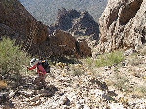
Though not long, this should be regarded as a difficult hike. There are no established trails, so the venture involves cross country route finding and plenty of bushwhacking, though you are likely to appreciate the many faint game trails that criss-cross the peak's flanks. To reach the summit, one must negotiate steep and brushy terrain, and near the top, there are 2nd and 3rd class sections of rock scrambling to deal with. Hikers must also take care on slopes and gullies steep enough that dislodged rocks can roll and bound downhill for some distance.
remove free decal offer
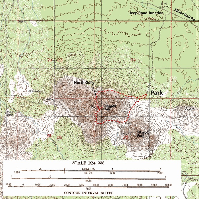
To start the loop route, walk south to the broad saddle between Ragged Top and Wolcott Peak, and then turn west, first contouring under the summit of Ragged Top and later working up a steep slope towards the crest of a prominent ridge sweeping south from the summit ridge. As you near the crest of the aforementioned ridge, look for the prominent South Gully, which cuts up directly towards the high saddle just west of the summit. From the high saddle, work east a little before climbing a steep ravine towards the summit. Near the top, there is a section of 2nd and 3rd class rock scrambling. On the descent, back at the high saddle, complete the loop by dropping down the steep and brushy North Gully, finally using game trails to contour east around the base of Ragged Top back to the car.
WARNING! Hiking and outdoor related sports can be dangerous. Be responsible and prepare for the trip. Study the area you are entering and plan accordingly. Dress for the current and unexpected weather changes. Take plenty of water. Never go alone. Make an itinerary with your plan(s), route(s), destination(s) and expected return time. Give your itinerary to trusted family and/or friends.
Permit $$
no fees or permits reported
if incorrect tell us about it
Directions
Road
FR / Dirt Road / Gravel - Car Okay
To hike Take the Marana Exit 236 from I-10 and go west. Turn left on Sandario and make a right onto Trico/Marana Rd. Take this to Silverbell Rd. and turn right. Silverbell will turn into a good dirt road. Take this past a gas pipeline and after crossing a cattle guard, look for the turnoff at 32.46756 N, 111.47487 W. If you have a high-clearance vehicle, you can take a left at this spot and continue 1.1 miles to a parking area near a fenceline. If not, add 2.2 miles onto the roundtrip distance.
2010-11-28 Don Graydon writes This is just a refinement of the directions above. Coming from Tucson, take the I-10 Marana exit 236 (about 15 miles northwest of Tucson). At the bottom of the offramp, turn left (this is Sandario Road), drive under the freeway, then turn right (just before the Circle K) onto Marana Road. Take Marana for 5.7 miles to Silverbell and turn right. Stay on Silverbell for 7.7 miles, where it becomes a dirt road. Stay on Silverbell for another 3.3 miles (just past a cattle guard). Turn left on a rough dirt road (should use a high-clearance vehicle) for 1.2 miles and park next to a fence (beneath the east face of Ragged Top).
 Route Editor


 Overview