Overview
The trail enters the Superstition Wilderness and descends into Rogers Canyon on trail #109. It reaches an intersection with trail #110 and then turns northeast and travels up onto Reavis Saddle and on to the ruins of Reavis Ranch. From the ranch area trail #109 heads north to a junction with trail #117 (the Reavis Gap Trail). The route follows this trail across Pine Creek towards Reavis Gap. At a trail junction with trail #119 (the Two Bar Ridge Trail), the route turns and goes past Walnut Spring, Two Bar Mountain, and along the high Two Bar Ridge. Just beyond Pinyon Mountain trail #119 ends at the Black Bush ranch road (FR 83).
The route follows this road and then turns north on trail #120 (the Cottonwood Trail). This trail goes through Cottonwood Canyon, by Cottonwood Spring, and then onto FR 341. This road climbs out of Cottonwood Canyon and then descends to trail #121 (the Thompson Trail). Trail #121 parallels Roosevelt Lake, passes the Roosevelt Cemetary, and then works its way over and down to the Thompson Trailhead. From here the route follows Highway 88 over the Roosevelt Lake Bridge to the Vineyard Trailhead.
When hiking several trails on a single "hike", log it with a generic name that describes the hike. Then link the trails traveled, check out the example.
WARNING! Hiking and outdoor related sports can be dangerous. Be responsible and prepare for the trip. Study the area you are entering and plan accordingly. Dress for the current and unexpected weather changes. Take plenty of water. Never go alone. Make an itinerary with your plan(s), route(s), destination(s) and expected return time. Give your itinerary to trusted family and/or friends.
Permit $$
no fees or permits reported
if incorrect tell us about it
Directions
Road
To Rogers Trough Trailhead Take US 60 east out of Apache Junction. A couple of miles past Florence Junction turn north onto Queen Valley Road and follow 1.6 miles. Turn right onto FS 357 (Hewlett Station Road) and follow about three miles to FS 172. Turn left onto FS 172 and follow this for 9.1 miles (keep an eye out to your right near the four-mile mark for a thin arch) to FS 172A.
Turn right onto FS 172A and follow 3.8 miles to the Rogers Trough Trailhead. While an occasional abused sedan negotiates the drive, high clearance is highly recommended. Without 4WD you might be in serious trouble if it rains.
This scenic drive wrecks havoc on passengers with weak stomachs.
 Route Editor

 Overview
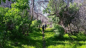


