a confident, yet calm favorite primary crinkle by HAZ_Hikebot
Overview
From General Springs Cabin the trail follows General Springs Canyon until it reaches a trail junction. It then climbs out of the canyon on the west side and follows a two-track road and then more trail. The trail crosses FR 123 and heads north until it reaches FR 123A. It stays on this forest road up to East Clear Creek. After steeply descending and then steeply ascending the creek (upstream of Blue Ridge Reservoir) the trail works its way up to FR 751. After crossing the road it proceeds east and then north up to the drop into Blue Ridge Campground. From here the trail continues north and finally reaches Highway 87 at the junction with FR 138.
Southern Trailhead FR 300 Trailhead
From the intersection of AZ 87 and AZ 260 north of Pine, drive east 2.6 miles on AZ 87 then turn right (south) toward FR 300. Go 0.1 miles and turn left onto FR 300. Avoid the frequent side roads and drive 12 miles on FR 300 to a turnoff on the left (north) at a historical marker for the Battle of Big Dry Wash. This is where the AZT crosses FR 300. Turn left and follow a power line 0.3 mile to General Springs Cabin. The road curves right to a small parking area and the trailhead.
Northern Trailhead Highway 87
From the intersection of AZ 87 and AZ 260 north of Pine, drive northeast 19.5 miles on AZ 87 then turn right (south) on FR 138. (This is about 0.8 miles west of the Blue Ridge Ranger Station on AZ 87.) Signs on the highway point to Moqui Campground. The trailhead is about 100 yards south on FR 138, on the left (east) side of the road.
When hiking several trails on a single "hike", log it with a generic name that describes the hike. Then link the trails traveled, check out the example.
WARNING! Hiking and outdoor related sports can be dangerous. Be responsible and prepare for the trip. Study the area you are entering and plan accordingly. Dress for the current and unexpected weather changes. Take plenty of water. Never go alone. Make an itinerary with your plan(s), route(s), destination(s) and expected return time. Give your itinerary to trusted family and/or friends.
Permit $$
no fees or permits reported
if incorrect tell us about it
Directions
Road
To hike
page created by joebartels on Jan 09 2010 12:41 am
 Route Editor

 Overview
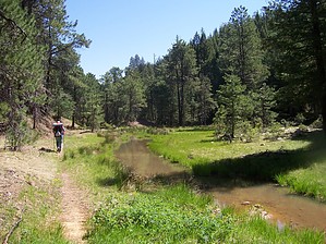


