 Route Editor

| Guide | ♦ | 44 Triplogs | 3 Topics |
details | drive | no permit | forecast | 🔥 route |
stats |
photos | triplogs | topics | location |
| 441 | 44 | 3 |
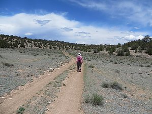
  Overview OverviewThis passage begins just east of the Cedar Ranch area where FR 417 and FR 9008A intersect. From here the route follows a pipeline road north to the Tub Ranch Camp. The route continues towards the corrals (east of the buildings). Once past the developments, the route goes west towards Chapel Mountain. After passing the high tension powerlines, the route travels north to Upper Lockwood Tank, then turns northeast to the Lower Lockwood Tank and then northwest before reaching the Kaibab National Forest boundary. At the boundary (a gate to the west of the cattle guard), there is a single-track trail immediately west of FR 301. The trail stays west of FR 301, then crosses it, and finally arrives at Moqui Stage Station. Southern Trailhead: Cedar Ranch - FR 417
Note This page is open to authors. Hike must be listed South to North as one-way. Do not include an overview as the above is permanent. Gate Policy: If a gate is closed upon arrival, leave it closed after you go through. If it is open, leave it open. Leaving a closed gate open may put cattle in danger. Closing an open gate may cut them off from water. Please be respectful, leave gates as found. The exception is signage on the gate directing you otherwise. Check out the Official Route and Triplogs. Leave No Trace and +Add a Triplog after your hike to support this local community. One-Way Notice This hike is listed as One-Way. When hiking several trails on a single "hike", log it with a generic name that describes the hike. Then link the trails traveled, check out the example. | |||||||||||||||||||||||||||||||||||||||||||||||||||||||||||||||||||||||||||||||||||||||||||||||||||||||||||||||||||||||||||||||||||||||||||||||||||||||||||||||||||||||||||||||||||||||||||||


