 Route Editor

| Guide | ♦ | 119 Triplogs | 6 Topics |
details | drive | no permit | forecast | 🔥 route |
stats |
photos | triplogs | topics | location |
| 1.1k | 119 | 6 |
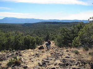
 2021 Note 2021 NoteThe middle portion was re-routed. The Official Route is current as of 2021-05-02. Overview Starting on the north side of the East Verde River the trail follows the Rock Creek drainage up to Polk Spring and then climbs up on Polles Mesa. It reaches Red Saddle Tank and a gate, another gate, turns to the east and comes to Whiterock Spring. There is a steep climb back to the west and then the trail begins working its way across Whiterock Mesa. After crossing a drainage the trail climbs again along Saddle Ridge. There is another gate and the trail continues mostly north to the wilderness boundary and another gate. The trail passes through Saddle Ridge Pasture, another gate, and then reaches FR 194. The route follows FR 194 for ~1.2 miles before turning right (southeast) onto a two-track running under a powerline. The route follows this rocky road in a southeast direction, then turns to the right onto FR 251 and veers away from the powerlines and then back towards them. The route turns to the south and descends to a barricaded gate, turns east past East Tank and through another barricaded gate. The trail descends past Ridge Tank and around to Oak Spring and a trail junction with Walnut Trail (#251). From here the trail climbs out of Oak Spring Canyon, runs more-or-less level for nearly a mile before descending past Bradshaw Tank to Pine Creek. A short way downstream the trail heads east again and loops around to Highway 87. After crossing the highway it passes a resupply box near a fence corner and then quickly hits a junction (stay left through a heavy steel gate) and loop back to the Pine trailhead.
The East Verde River - LF Ranch East Verde River (LF Ranch), via Doll Baby Trailhead: From the town of Payson at the intersection of AZ 87 and Main Street; take Main Street west for 2 miles, which turns into Country Club Drive. Near the end of Country Club Drive, the road passes a sanitation plant, crosses a creek, and continues on a paved road for another 6 miles. This newly paved road is referred to as Doll Baby Ranch Rd. or LF Ranch Rd. depending on which map is being used. At this point, it becomes dirt doubletrack (FR 406). Continue on FR 406 for approximately 3 miles, passing City Creek Trailhead and Doll Baby Ranch, eventually arriving at the locked gate. This is the Doll Baby Trailhead; parking and camping are allowed. From the trailhead, walk around the gate and hike on the doubletrack for 3.9 miles. The road will wind around the hills and eventually level out in the valley near the ranch. The AZT will intersect the road from the west as faint singletrack. Northern Trailhead Pine Trailhead Drive south of Pine on AZ 87 for 0.6 miles and turn left (east) to reach a large parking area and the trailhead. Updated 2017-07-24 Note data from old Hardscrabble Mesa - AZT #26 merged to this page Gate Policy: If a gate is closed upon arrival, leave it closed after you go through. If it is open, leave it open. Leaving a closed gate open may put cattle in danger. Closing an open gate may cut them off from water. Please be respectful, leave gates as found. The exception is signage on the gate directing you otherwise. Check out the Official Route and Triplogs. Note This is a moderately difficult hike. Leave No Trace and +Add a Triplog after your hike to support this local community. One-Way Notice This hike is listed as One-Way. When hiking several trails on a single "hike", log it with a generic name that describes the hike. Then link the trails traveled, check out the example. | |||||||||||||||||||||||||||||||||||||||||||||||||||||||||||||||||||||||||||||||||||||||||||||||||||||||||||||||||||||||||||||||||||||||||||||||||||||||||||||||||||||||||||||||||||||||||||||||||||||||


