Overview
This is a relatively flat loose gravel wash hike that is between Willow Springs Canyon Upper and Willow Springs Canyon Lower. It can be driven or used to set up a shuttle if you have a capable 4 X 4. Getting to it is strickly 4 X 4 from the trailhead.
When hiking several trails on a single "hike", log it with a generic name that describes the hike. Then link the trails traveled, check out the example.
WARNING! Hiking and outdoor related sports can be dangerous. Be responsible and prepare for the trip. Study the area you are entering and plan accordingly. Dress for the current and unexpected weather changes. Take plenty of water. Never go alone. Make an itinerary with your plan(s), route(s), destination(s) and expected return time. Give your itinerary to trusted family and/or friends.
Permit $$
None
Directions
Road
FR / Dirt Road / Gravel - Car Okay
To hike Special Use: This Trail is part of the Bull Dog Canyon OHV area and an administrative permit can be obtained at no cost from the Mesa Tonto Forest Office. The permit will allow further access beyond the gate for those with a four wheel drive vehicle. Apache trail Northeast from Idaho Road in Apache Junction. About 10 miles northeast to highway marker 204. Just before the marker turn left into parking area. A reference point is the Needle Vista viewpoint on the south of the highway. The trailhead is not marked but is a clear pulloff area just before the 204 sign.
 Route Editor

 Overview
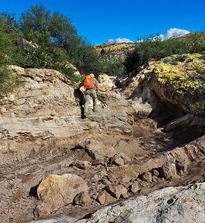


